Tucumcari Mountain
| Tucumcari Mountain | |
|---|---|
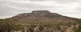 Mesa Tucumcari viewed from the west. | |
| Highest point | |
| Elevation | 4,976 ft (1,517 m) NAVD 88[1] |
| Coordinates | 35°08′04″N 103°41′55″W / 35.13453091°N 103.69871754°WCoordinates: 35°08′04″N 103°41′55″W / 35.13453091°N 103.69871754°W [1] |
| Geography | |
 Tucumcari Mountain Location in New Mexico | |
| Location | Quay County, New Mexico, U.S. |
| Topo map | USGS Tucumcari |
| Geology | |
| Age of rock | Cretaceous |
| Climbing | |
| Easiest route | Drive (private land) |
Tucumcari Mountain, once referred to as Tucumcari Peak or Mesa Tucumcari, is a mesa situated just outside Tucumcari, New Mexico.[2]
Where the mountain got its name is uncertain. It may have come from the Comanche word "tukamukaru", which means to lie in wait for someone or something to approach. A 1777 burial record mentions a Comanche woman and her child captured in a battle at Cuchuncari, which is believed to be an early version of the name Tucumcari.[3]
Pedro Vial referred to the mountain in 1793, while opening a trail between Santa Fe and St. Louis. Captain Randolph B. Marcy led an expedition past it in 1849.[4] The Swiss-American geologist Jules Marcou studied the geology of Tucumcari Mountain in 1853 and claimed that the Tucumcari strata were of Jurassic age.[5] The Texas geologist, Robert T. Hill, visited "Mesa Tucumcari" in 1887 and again in 1891, and eventually concluded that the Tucumcari strata were much younger Cretaceous deposits, not Jurassic as suggested by Marcou.[6][7] Also in 1891, William F. Cummins of the Geological Survey of Texas studied Tucumcari Mountain and his careful observations of the strata established beyond doubt the Cretaceous age of the Tucumcari beds.[8]
The town of Tucumcari was founded in 1901 and, in 1908, took its name—both in real life and in legend—from the mountain.[9] Residents of the town of Tucumcari have painted a hillside letter T on the mountain. A cartoon version of this mountain appears in Cars with 'RS' (for Radiator Springs) substituted for Tucumcari's 'T'.[10]
See also
References
- 1 2 "Tucumcari". NGS data sheet. U.S. National Geodetic Survey. Retrieved 2014-02-15.
- ↑ "The First Santa Fe Expedition: 1792-1793". Chronicles of Oklahoma. Oklahoma Historical Society. Retrieved 2014-02-13.
- ↑ Julyan, Robert. "Tucumcari". New Mexico State Record Center and Archives. Retrieved 2014-02-13.
- ↑ "Mesalands Scenic Byway". NewMexico.org. Retrieved 2014-02-13.
- ↑ Marcou, Jules (1858). Geology of North America. Zurich: Zürcher and Furrer. p. 121. OCLC 15278797.
- ↑ Hill, Robert T. (1892). On the occurrence of artesian and other underground waters in Texas, New Mexico, and Indian Territory, together with the geology and geography of those regions. Final Reports of the Artesian and Underflow Investigations of the U. S. Department of Agriculture. p. 166. OCLC 17204624.
- ↑ Hill, Robert T. 1893. Tucumcari. Science 22(545):23-25.
- ↑ Cummins, W.F. (1892). Dumble, E.T., ed. Notes on the geology west of the plains: Tucumcari, New Mexico. Third annual report of the Geological Survey of Texas. pp. 201–210. OCLC 6300790.
- ↑ Legend "The Legend of Tucumcari" Check
|url=value (help). Retrieved 2014-02-13. - ↑ http://articles.latimes.com/2013/jan/05/news/la-trb-route-66-cars-land-disney-california-adventure-11201228