Tununak Airport
| Tununak Airport | |||||||||||
|---|---|---|---|---|---|---|---|---|---|---|---|
 | |||||||||||
| IATA: TNK – ICAO: none – FAA LID: 4KA | |||||||||||
| Summary | |||||||||||
| Airport type | Public | ||||||||||
| Owner | State of Alaska DOT&PF - Central Region | ||||||||||
| Serves | Tununak, Alaska | ||||||||||
| Elevation AMSL | 14 ft / 4 m | ||||||||||
| Coordinates | 60°34′32″N 165°16′18″W / 60.57556°N 165.27167°W | ||||||||||
| Runways | |||||||||||
| |||||||||||
| Statistics | |||||||||||
| |||||||||||
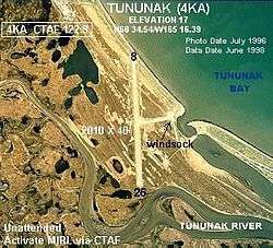
Tununak Airport (IATA: TNK, FAA LID: 4KA) is a state-owned, public-use airport located one nautical mile (1.85 km) southwest of the central business district of Tununak, in the Bethel Census Area of the U.S. state of Alaska.[1]
As per Federal Aviation Administration records, this airport had 1,809 commercial passenger boardings (enplanements) in calendar year 2008, a decrease of 9.6% from the 2,001 enplanements in 2007.[2] Tununak Airport is included in the FAA's National Plan of Integrated Airport Systems (2009–2013), which categorizes it as a general aviation facility.[3]
Although most U.S. airports use the same three-letter location identifier for the FAA and IATA, this airport is assigned 4KA by the FAA and TNK by the IATA.[4]
Facilities
Tununak Airport has one runway designated 8/26 with a gravel surface measuring 1,778 by 30 feet (542 x 9 m). The airport is unattended.[1]
Remarks:[1]
- Surface has dips, soft spots, rocks 4-8 inches length of runway.
- 08/26 reflective markers on runway edge.
- Activate MIRL runway 08/26 - CTAF.
- Caution: runway condition not monitored; recommend visual inspection prior to using.
- Road 600' long used for landings and takeoff during strong crosswinds.
- Pilots are requested to self-announce on CTAF prior to taxiing on runway for departure; leaving the runway and within 10 NM of the airport when approaching to land.
- Windsock unreliable.
References
- 1 2 3 4 FAA Airport Master Record for 4KA (Form 5010 PDF). Federal Aviation Administration. Effective 27 Aug 2009.
- 1 2 CY 2008 Passenger Boarding and All-Cargo Data (Preliminary). Federal Aviation Administration. Published 15 July 2009.
- ↑ FAA National Plan of Integrated Airport Systems: 2009-2013. Federal Aviation Administration. Published 1 Oct 2008.
- ↑ Great Circle Mapper: TNK - Tununak, Alaska. Retrieved 2 Sep 2009.
External links
- FAA Alaska airport diagram (GIF)
- Resources for this airport:
- FAA airport information for 4KA
- AirNav airport information for 4KA
- ASN accident history for TNK
- FlightAware airport information and live flight tracker
- SkyVector aeronautical chart for 4KA