Twante Canal
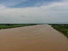
The Twante Canal (Burmese: တွံတေး တူးမြောင်း [tʊ̀ɴté tú mjáʊɴ]) is a canal that connects the Irrawaddy River and the Yangon river in Myanmar. The 35 km (22 mi) canal is a heavily used short cut between the city of Yangon and the Irrawaddy Division. The canal is named after the town of Twante, located near the canal's mid-way point. The canal was the quickest route from Yangon to the Irrawaddy Delta until the 1990s when roads between Yangon and the Irrawaddy Division became usable year round. The canal is still heavily used.
Due to the lack of regular maintenance, the canal has become silted and narrower over the years. In 2010, the mouth of the canal was widened by 600 feet (180 m). However, plans to put in concrete embankments were yet to be carried out, and the navigation problems still remain.[1] Twante Bridge is only bridge that spans the Twante Canal[2]
History
The construction work on Twante Canal began in 1881 during the British colonial rule. The canal was opened in May 1883.[3] The Twante Canal shortened the distance by the Kanaungto creek between Yangon and the Irrawaddy river.[4] The Irrawaddy Flotilla Company, Ltd., which handled nearly all inland carrier traffic in British Burma, ran daily services from Yangon to the Irrawaddy delta and Upper Burma.[5] In 1935, the canal was widened and deepened to allow for the Irrawaddy Flotilla Company's large steamers to Mandalay. Previously larger steam ships had to go out the Yangon river and up one of the larger mouths of the Irrawaddy.[6]
References
- ↑ "Widened Twante Canal Still Needs Concrete Levees". Bi-Weekly Eleven (in Burmese). Eleven Media Group. 2010-11-23.
- ↑ "Twante Bridge Photo".
- ↑ William Wilson Hunter; James Sutherland Cotton; Richard Burn; William Stevenson Meyer (1908). Imperial Gazetteer of India. Great Britain: Clarendon Press. p. 188.
- ↑ Hunter, et al, p. 250
- ↑ Andrus. Burmese Economic Life. Stanford University Press. pp. 206–207. ISBN 9780804703154.
- ↑ Paul H. Kratoska (2001). South East Asia, Colonial History: Colonial History. Taylor & Francis. p. 169. ISBN 9780415215428.
Coordinates: 16°43′26″N 95°57′54″E / 16.72389°N 95.96500°E