Twerton-on-Avon railway station
| Twerton-on-Avon | |
|---|---|
|
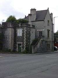
Twerton-on-Avon station from Lower Bristol road opposite Twerton High Street. | |
| Location | |
| Place | Twerton |
| Area | Bath |
| Operations | |
| Original company | Great Western Railway |
| Pre-grouping | Great Western Railway |
| Post-grouping | Great Western Railway |
| Platforms | 2 |
| History | |
| 1840 | Opened (Twerton) |
| 1899 | Renamed (Twerton-on-Avon) |
| 1917 | Closed |
| Disused railway stations in the United Kingdom | |
|
Closed railway stations in Britain A B C D–F G H–J K–L M–O P–R S T–V W–Z | |
|
| |
Twerton on Avon railway station is a former railway station in Bath, Somerset.
Architecture and Opening
Twerton was named after the village that it served (west of Bath on the south bank of the Avon) though at the time it was also called Twiverton. The station was built in Gothic style variously called Tudor or Jacobethan. This style is seen from the tunnel mouths west of Twerton to Bath Spa station including many arches and embellishment in the viaduct itself. This is something of a contrast to the Georgian buildings in the centre of Bath north of the river, but is reflected in the Victorian domestic architecture on the southern suburbs. It opened as a railway station on 16 December 1840 for Great Western Railway services from Bristol.[1] Four trains a day stopped at Twerton in each direction (out of eleven services each way between Bath and Bristol).
Subsequent history
Twerton station was operated by the Great Western Railway but was renamed Twerton on Avon in 1899 to avoid confusion with Tiverton.[1]
Closure
Railway Stations in Bath |
|---|
The station was closed in 1917 as an economy measure during the First World War. Passenger traffic into Bath had been reduced by competition from the electric tram line which terminated in Twerton, and the station was not reopened after the end of the war. In 1929 Oldfield Park station was opened nearby (but closer to Bath).
| Preceding station | Historical railways | Following station | ||
|---|---|---|---|---|
| Saltford | Great Western Railway Great Western Main Line |
Oldfield Park | ||
Current uses
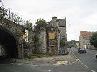
The station building like the viaduct on which it sits is a Grade II listed structure, but was boarded up as of May 2006 and appears to be abandoned. A roadside cafe operates from its forecourt, but does not occupy any original parts of the station.
References
Coordinates: 51°22′49″N 2°23′27″W / 51.3803°N 2.3908°W