Typometry (printing)
Typometry was a short-lived relief printing technique developed during the 18th and 19th centuries to compose maps, drawings and other designs, using moveable type to reproduce words, lineworks and map symbols.[1][2]
History
In the 18th century, the German deacon August Gottlieb Preuschen (1734–1803), from Karlsruhe, published two books on the art of printing maps using movable type.[3] The books were printed in Basel, Switzerland, using type from the foundry Haas'sche Schriftgiesserei, by Wilhelm Haas.
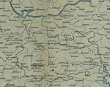
After some rudimentary tests by Preuschen, the 1776 map of the Canton of Basel[4] (in cuarto format) was the first map created by this technique.[3] Some others would follow, such as the 1777 map of Sicily,[5] which features toponyms printed with moveable type as well as roads, coasts, divisions and rivers printed with folding metal filaments. Special moveable topographic symbols mark the mountain ranges of the island, its fortifications, and other landmarks.
The printer Johann Gottlob Immanuel Breitkopf, based in Leipzig (Germany) was at first critical with the invention, claiming that it was impossible to accurately adapt and assemble different shapes of types to create a new form.[6] But, after the typometric prints were proven to be successful, he began experimenting himself with the technique.[7]
In the early 19th century, two different issues of a French review called the Bulletin de la Société d’Encouragement pour l’Industrie Nationale contains articles about typometry. The first one, of 1808, refers to the research work of Mr. Periaux and Mr. Poterat, to produce typometric maps, in order to generate a viable alternative to engraved maps.[8] The second article, of 1825, introduces the advancements made by Firmin Didot, son, in the technique of printing maps by using typographic means.[9]
The polychrome maps of France[10] made by Didot were sold at the price of 1 franc and 50 cents, which was more affordable than the monochrome engraved maps of the time.[11] Typometric maps, even with their inferior detail quality, were also considerably faster to produce than engraved maps. In Vienna, the Slovak cartographer Franz Raffelsperger (1793-1861) also helped to perfect the technique during the 19th century, and he founded a typometric press in that city in 1840.[2] However, with the advent of lithography, invented by Alois Senefelder in 1796, typometry was confronted with another method that was even better at reproducing detail and that allowed to print several solid colours at a low price, so it was progressively abandoned.[7]
Notes and references
- ↑ Woodward, David (2007). The History of Cartography, Volume 3 (PDF). p. 600.
- 1 2 Hammann, J. M. Hermann (1857). Des arts graphiques destinés à multiplier par l'impression, considérés sous le double point de vue historique et pratique (in French). J. Cherbuliez (Geneva). pp. 128–131.
On comprend sous le nom collectif et générique de typomètre l'art de composer et imprimer, au moyen de types mobiles, les cartes géographiques, les dessins mathématiques et géométriques, ceux des plans des machines, d'objets d'histoire naturelle, et même des portraits. [English: We understand typometry, collectively and generically, as the art of composing and printing, by means of mobile type, geographical maps, mathematical and geometrical drawings, plans for machines, natural history objects, and even portraits.]
- 1 2 Mayeul Chaudon, Louis (1810). Dictionnaire universel, historique, critique et bibliographique. [Universal, historical, critical and bibliographic dictionary] (in French). VIII. pp. 198–199.
- ↑ Prodromus tentaminis typometrici maioris Rempublicam Basileensem / secundum Aug. Gotl. Preuschenii nec non Gullielmi Haasii systema typometricum describens (18 x 22 cm) (Map). Ca. 1:180 000 (in Latin and German). 1776. Retrieved October 31, 2016.
- ↑ Jaillot, Alexis-Hubert; Preuschen, August Gotlieb; Haas, Guillaume (1777). Carte de la Sicile, composée d'après celle de Jaillot avec des caractères mobiles suivant le nouveau système typométrique de Auguste Gottlieb Preuschen diacre à la cour de Bade / perfectionné et executé par Guillaume Haas (Map) (in French).
- ↑ Biographie universelle, ancienne et moderne: ou, Histoire, par ordre alphabétique, de la vie publique et privée de tous les hommes qui se sont fait remarquer par leurs écrits, leurs actions, leurs talents, leurs vertus ou leurs crimes. Ouvrage entièrement neuf, redigé par une société de gens de lettres et de savants. L. G. Michaud, Paris. 1823. p. 54.
- 1 2 Von Ralf Herrmann (February 7, 2013). "Typometrie - ein vergessenes Stück Druckkunst-Geschichte" [Typometry - a forgotten piece of printing art history]. typographie.info (in German). Retrieved October 31, 2016.
- ↑ "Cartes typo-géographiques". Bulletin de la Société d’Encouragement pour l’Industrie Nationale, septième année (in French). 1808. Retrieved October 31, 2016.
- ↑ "Typographie". Bulletin de la Société d’Encouragement pour l’Industrie Nationale, vingt-quatrième année: 62. 1825. Retrieved October 31, 2016.
- ↑ Langlois, Joseph; Barbié Du Bocage, Jean-Denis; Firmin-Didot (1823). artes Typo-géographiques, inventées et imprimées / par Firmin Didot. France. 25 Lieues [=Om. 037 ; 1 : 3 000 000 ] ; Jos. Langlois delin. ; Barbié du Bocage dir (Map). 1 : 3.000.000 (in French).
- ↑ "Charten-Recensionen". Neue allgemeine geographische und statistische Ephemeriden [New general geographic and statistical ephemerides] (in German). 13. 1824. pp. 216 – 217.
External links
- The Land of Enthusiasm and the Empire of Love, an article on Breitkopf's typometric efforts.
- Wilhelm Haas, Mapmaker