Tyska Brinken
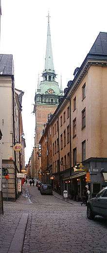
Tyska Brinken (Swedish: The German Slope) is a street in Gamla stan, the old town in central Stockholm, Sweden. Extending Kindstugatan past the German Church down to the square Mälartorget, it is crossed by Skomakargatan, Prästgatan, Västerlånggatan, Stora Nygatan, Lilla Nygatan, and Munkbrogatan, while forming a parallel street to Schönfeldts Gränd and Lejonstedts Gränd.
History
Mentioned as Vattubrinken ("Water Slope") and Skomakarbrinken (Shoemaker's Slope") in the 15th and 16th centuries, the street appears as Tyske Kyrkebrinken in 1612, and finally as Tyska brinken in 1679), and Tyska Brinken in 1880. The street is named after the vicinity to the German Church, and the German parish. The German influence in Stockholm was considerable during the Middle Ages - half of both the population and the members of the City Council were German; the Hanseatic League dominated trade; the wealthiest burghers were Germans; and the German language and culture was present everywhere. German merchants in the city gathered at the Guild of St Gertrud found on the present location of the church. In 1571, King John III sanctioned a German parish and a German graveyard, and by 1638-1642 the Germans had completed the present church. The section west of Stora Nygatan was renamed Jochum Bryggares gränd ("Alley of Jochum Brewer") around 1700 after the German-born master brewer Jochum Ahlstedt (-1680).[1]
Archaeological excavations in the crossing Lilla Nygatan/Tyska Brinken in 1993, unveiled remains of an old city wall and traces of what was interpreted as a defensive tower from the 14th century known as Bocktornet ("Buck (He-goat) Tower"). Later investigations have however made in more likely to be structures from the defensive system constructed in the 1560s.[2]
As the street forms an extension to Kindstugatan, the first numbers on the eastern end of the street begins with number 20. The Rococo building on Number 20-22, called "Building of the German Church", was created in 1869 when three medieval properties were united to a single, the blind windows still unveils the seams. The 1870s building in the corner to 18, Lilla Nygatan, is the design of Albert Törnqvist (1819–1898).[3]
See also
References
- ↑ "Innerstaden: Gamla stan". Stockholms gatunamn (2nd ed.). Stockholm: Kommittén för Stockholmsforskning. 1992. pp. 78–79. ISBN 91-7031-042-4.
- ↑ John Hedlund (2002). "Cerberus 1, 3, 4 & Lejonstedts Gränd" (PDF) (in Swedish). Stockholm City Museum. Retrieved 2007-02-21. (including maps of the assumed extension of the historical city walls)
- ↑ Béatrice Glase, Gösta Glase (1988). "Inre Stadsholmen". Gamla stan med Slottet och Riddarholmen (in Swedish) (3rd ed.). Stockholm: Bokförlaget Trevi. p. 62. ISBN 91-7160-823-0.
External links
-
 Media related to Tyska Brinken at Wikimedia Commons
 - hitta.se - location map
Coordinates: 59°19′25″N 18°04′13″E / 59.32361°N 18.07028°E