Virginia State Route 261
| ||||
|---|---|---|---|---|
| Statler Boulevard | ||||
 | ||||
| Route information | ||||
| Maintained by VDOT | ||||
| Length: | 2.21 mi[1] (3.56 km) | |||
| Existed: | c. 1980 – present | |||
| Major junctions | ||||
| South end: |
| |||
|
| ||||
| North end: | Coalter Street in Staunton | |||
| Location | ||||
| Counties: | City of Staunton | |||
| Highway system | ||||
| ||||

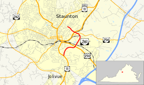
State Route 261 (SR 261) is a primary state highway in the U.S. state of Virginia. Known as Statler Boulevard, the state highway runs 2.21 miles (3.56 km) from U.S. Route 11 (US 11) north to Coalter Street within the independent city of Staunton. SR 261 is an unsigned four-lane divided highway that provides an eastern truck bypass of downtown Staunton. The state highway is marked along much of its route as U.S. Route 11 Truck and US 250 Truck.
Route description
_at_the_junction_with_U.S._Route_250_(Richmond_Avenue)_in_Staunton%2C_Virginia.jpg)
SR 261 begins an intersection with US 11 (Greenville Avenue) and unnumbered Old Greenville Road southeast of downtown Staunton. This intersection is also the southern terminus of US 11 Truck. The four-lane divided highway intersects US 250 (Richmond Road), where the state highway also begins to run concurrently with US 250 Truck. SR 261 crosses over CSX's North Mountain Subdivision and curves west to intersect SR 254 (New Hope Road), the Chesapeake Western Railway, and US 11 (Commerce Road). At the US 11 intersection, US 11 Truck reaches its northern terminus and US 250 Truck turns north onto US 11. US 250 Truck follows US 11 and SR 262 north and west to reconnect with US 250 northwest of Staunton. SR 261 continues west to its northern terminus at the intersection of Coalter Street and Edgewood Road northeast of downtown Staunton.[1][2]
Major intersections
The entire route is in Staunton.
| mi[1] | km | Destinations | Notes | ||
|---|---|---|---|---|---|
| 0.00 | 0.00 | south end of US 11 Truck overlap | |||
| 0.84 | 1.35 | south end of US 250 Truck overlap | |||
| 1.62 | 2.61 | ||||
| 1.76 | 2.83 | north end of US 11 Truck / US 250 Truck overlap | |||
| 2.21 | 3.56 | North Coalter Street / Edgewood Road | |||
| 1.000 mi = 1.609 km; 1.000 km = 0.621 mi | |||||
References
- 1 2 3 "2010 Traffic Data". Virginia Department of Transportation. 2010. Retrieved 2011-12-22.
- ↑ Google (2011-12-22). "Virginia State Route 261" (Map). Google Maps. Google. Retrieved 2011-12-22.