U.S. Route 522 in Maryland
| |||||||
|---|---|---|---|---|---|---|---|
 | |||||||
| Route information | |||||||
| Maintained by MDSHA | |||||||
| Length: | 2.35 mi[1] (3.78 km) | ||||||
| Existed: | 1927 – present | ||||||
| Tourist routes: |
| ||||||
| Major junctions | |||||||
| South end: |
| ||||||
|
| |||||||
| North end: |
| ||||||
| Location | |||||||
| Counties: | Washington | ||||||
| Highway system | |||||||
| |||||||

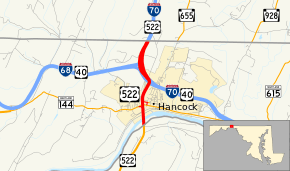
U.S. Route 522 (US 522) is a part of the U.S. Highway System that runs from Powhatan, Virginia to Selinsgrove, Pennsylvania. In Maryland, it runs 2.35 miles (3.78 km) from the West Virginia state line at the Potomac River north to the Pennsylvania state line within Hancock in western Washington County. US 522 crosses Maryland at its narrowest north–south point, meeting Maryland Route 144 (MD 144), Interstate 70 (I-70), US 40, and I-68 before entering Pennsylvania concurrent with I-70. Warfordsburg Road from US 40 (now MD 144) north to Pennsylvania was paved around 1920 and designated US 522 in the late 1920s. US 522 was extended south into West Virginia shortly after a new bridge was completed over the Potomac River in the late 1930s. It was moved onto I-70 north of Hancock when the Interstate highway was completed in the area in the mid 1960s.
Route description
US 522 enters Maryland by crossing the Potomac River on a long bridge at Hancock in western Washington County. The two-lane undivided bridge begins in West Virginia immediately after an intersection with River Road, then crosses CSX's Cumberland Subdivision and intersects a road to Potomac Airpark. The bridge crosses the state line on the south bank of the Potomac River, then continues above the Chesapeake and Ohio Canal National Historical Park, Berm Road, the Western Maryland Rail Trail, and South Street before the bridge ends. US 522 continues north as Warfordsburg Road,[2] with southbound US 522 receiving a two-way ramp (unsigned US 522B) from MD 144 (Main Street) before bridging MD 144, Little Tonoloway Creek, and Limestone Road, which is unsigned MD 894. It becomes a divided highway immediately before northbound US 522 has a right-in/right-out interchange with High Street (unsigned US 522C), which leads to MD 144 via Virginia Avenue. Southbound US 522 has an exit ramp to Limestone Road used to access MD 144. US 522 meets I-70 and US 40 (Eisenhower Memorial Highway) at a three-level directional interchange where US 522 becomes concurrent with the two other highways. Immediately to the north, I-70 and US 522 meet the eastern terminus of I-68 (National Freeway) at another three-level directional interchange (where westbound US 40 leaves I-70 and goes onto I-68). Southbound US 522 exits I-70 via a left exit (unsigned US 522A) prior to US 40 joining eastbound I-70, so southbound US 522 does not have a concurrency with US 40. I-70 and US 522 continue north as a four-lane freeway to the Pennsylvania state line.[1][3]
_just_north_of_the_Potomac_River_in_Hancock%2C_Maryland.jpg)
US 522 is a part of the main National Highway System for its entire length in Maryland.[1][4]
History
Warfordsburg Road from Main Street at the west end of Hancock north to the Pennsylvania state line was paved in 1920.[5][6] When the first number designations in the U.S. Highway System were released in 1926, US 622 was proposed for the highway between Hancock and Mount Union, Pennsylvania.[7] Another proposed number for the highway may have been US 11W, which appears marked on Warfordsburg Road on official Maryland maps in 1927 and 1928.[8][9] By 1930, the highway was marked as US 522.[10] The March 1936 flooding of the Potomac River destroyed the pre-existing bridge over the river at Church Street.[11][12] A temporary timber trestle was constructed while a new bridge was planned at the western edge of the town of Hancock.[12][13] The new bridge and approach roads were completed in 1939.[13][14][15] US 522 was extended south of Hancock by 1946.[16] US 522 was moved from Warfordsburg Road to a concurrency with I-70 when the Interstate highway and the associated directional interchanges were completed in 1965.[17][18]
Junction list
The entire route is in Hancock, Washington County.
| mi[1] | km | Destinations | Notes | ||
|---|---|---|---|---|---|
| 0.00 | 0.00 | Southern terminus of US 522 in Maryland; West Virginia state line at Potomac River | |||
| 0.39 | 0.63 | Southbound exit and entrance via right-in/right-out only; two-way ramp is unsigned US 522B | |||
| 0.57 | 0.92 | Northbound exit and entrance via right-in/right-out only; High Street is unsigned US 522C | |||
| 0.65 | 1.05 | Southbound exit only; Limestone Road is unsigned MD 894 | |||
| 1.19 | 1.92 | South end of concurrency with I-70 and US 40; ramp from eastbound I-70 to southbound US 522 is unsigned US 522A | |||
| 1.72 | 2.77 | North end of concurrency with US 40 | |||
| 2.35 | 3.78 | Northern terminus of US 522 in Maryland; Pennsylvania state line | |||
| 1.000 mi = 1.609 km; 1.000 km = 0.621 mi | |||||
Auxiliary routes
- US 522A was the designation for the unnamed 0.40-mile (0.64 km) left exit ramp from eastbound I-70 to southbound US 522 within I-70 Exit 1. The ramp is marked as Exit 1B.[19] The designation was retired in 2013 and is now inventoried as part of mainline US 522.[20][21]
- US 522B is the designation for the unnamed 0.14-mile (0.23 km) two-way ramp between MD 144 and US 522 at the north end of the bridge over the Potomac River. All movements are allowed at the intersection with MD 144. Left turns are prohibited at the ramp's intersection with US 522, so the ramp functions more like a right-in/right-out interchange for southbound US 522. The ramp also provides access to a hotel.[1][22]
- US 522C is the designation for a 0.20-mile (0.32 km) section of north–south Virginia Avenue and east–west High Street between MD 144 and a right-in/right-out interchange with northbound US 522.[1][23]
See also
 Maryland Roads portal
References
- 1 2 3 4 5 6 Highway Information Services Division (December 31, 2013). Highway Location Reference. Maryland State Highway Administration. Retrieved 2010-10-03.
- Washington County (PDF)
- ↑ http://msa.maryland.gov/megafile/msa/stagsere/se1/se5/023000/023900/023947/pdf/msa_se5_23947.pdf Maryland Trust - US 522 over Potomac River
- ↑ Google (2010-10-03). "U.S. Route 522 in Maryland" (Map). Google Maps. Google. Retrieved 2010-10-03.
- ↑ National Highway System: Maryland (PDF) (Map). Federal Highway Administration. October 1, 2012. Retrieved 2015-06-10.
- ↑ Zouck, Frank H.; Uhl, G. Clinton; Mudd, John F. (January 1920). Annual Reports of the State Roads Commission of Maryland (1916–1919 ed.). Baltimore: Maryland State Roads Commission. p. 20. Retrieved 2010-10-03.
- ↑ Maryland Geological Survey (1921). Map of Maryland: Showing State Road System and State Aid Roads (Map). Baltimore: Maryland Geological Survey.
- ↑ Bureau of Public Roads & American Association of State Highway Officials (November 11, 1926). United States System of Highways Adopted for Uniform Marking by the American Association of State Highway Officials (Map). 1:7,000,000. Washington, DC: U.S. Geological Survey. OCLC 32889555. Retrieved November 7, 2013 – via University of North Texas Libraries.
- ↑ Maryland Geological Survey (1927). Map of Maryland: Showing State Road System and State Aid Roads (Map). Baltimore: Maryland Geological Survey.
- ↑ Maryland Geological Survey (1928). Map of Maryland: Showing State Road System and State Aid Roads (Map). Baltimore: Maryland Geological Survey.
- ↑ Maryland Geological Survey (1930). Map of Maryland Showing State Road System: State Aid Roads and Improved County Road Connections (Map). Baltimore: Maryland Geological Survey.
- ↑ Hancock, WV quadrangle (Map) (1901 ed.). 1:48,000. 15 Minute Series (Topographic). United States Geological Survey. Retrieved 2010-10-03.
- 1 2 Tabler, H.E.; Wilkinson, C. Nice; Luthardt, Frank F. (December 4, 1936). Report of the State Roads Commission of Maryland (1935–1936 ed.). Baltimore: Maryland State Roads Commission. p. 53. Retrieved 2010-10-03.
- 1 2 Beall, J. Glenn; Jarboe, Elmer R.; Obrecht, George F., Sr. (March 4, 1939). Report of the State Roads Commission of Maryland (1937–1938 ed.). Baltimore: Maryland State Roads Commission. pp. 77–80. Retrieved 2010-10-03.
- ↑ Maryland State Roads Commission (1939). General Highway Map: State of Maryland (Map). Baltimore: Maryland State Roads Commission.
- ↑ Whitman, Ezra B.; Webb, P. Watson; Thomas, W. Frank (March 15, 1941). Report of the State Roads Commission of Maryland (1939–1940 ed.). Baltimore: Maryland State Roads Commission. p. 120. Retrieved 2010-10-03.
- ↑ Maryland State Roads Commission (1946). Maryland: Official Highway Map (Map) (1946–47 ed.). Baltimore: Maryland State Roads Commission.
- ↑ Maryland State Roads Commission (1966). Maryland: Official Highway Map (Map). Baltimore: Maryland State Roads Commission.
- ↑ "NBI Structure Number: 100000210090010". National Bridge Inventory. Retrieved 2010-10-03.
- ↑ Highway Information Services Division (December 31, 2012). Highway Location Reference. Maryland State Highway Administration. Retrieved 2014-08-09.
- Washington County (PDF)
- ↑ Highway Information Services Division (December 31, 2013). Highway Location Reference. Maryland State Highway Administration. Retrieved 2010-08-09.
- Washington County (PDF)
- ↑ Google (2010-11-30). "U.S. Route 522A" (Map). Google Maps. Google. Retrieved 2010-11-30.
- ↑ Google (2010-11-30). "U.S. Route 522B" (Map). Google Maps. Google. Retrieved 2010-11-30.
- ↑ Google (2010-11-30). "U.S. Route 522C" (Map). Google Maps. Google. Retrieved 2010-11-30.
External links
| Wikimedia Commons has media related to U.S. Route 522 in Maryland. |
| Previous state: West Virginia |
Maryland | Next state: Pennsylvania |