Udone-shima
| Native name: <span class="nickname" ">鹈渡根岛 | |
|---|---|
 | |
 | |
| Geography | |
| Location | Izu Islands |
| Coordinates | 34°28′21″N 139°17′38″E / 34.47250°N 139.29389°E |
| Archipelago | Izu Islands |
| Area | 0.4 km2 (0.15 sq mi) |
| Length | 1,500 m (4,900 ft) |
| Width | 550 m (1,800 ft) |
| Highest elevation | 210 m (690 ft) |
| Administration | |
|
Japan | |
| Demographics | |
| Population | 0 |
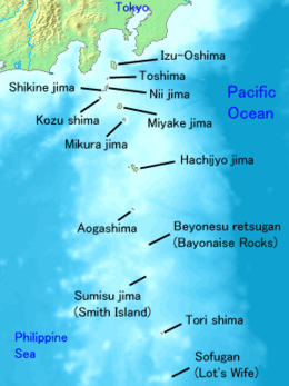
Udone-shima (鹈渡根岛) is a volcanic, deserted island located in the Philippine Sea approximately 150 kilometres (93 mi) south of Tokyo in between Toshima and Nii-jima, in the northern portion of the Izu archipelago, Japan.
Geography
The island is the remnant of an andesite lava dome with sheer sides, the only visible portion of a submarine volcanic caldera. The above sea-level portion has a surface area of approximately 0.4 square kilometers, with a summit height of 210 metres (690 ft). The main island is surrounded by a number of rocks.
Despite its small size, the island was formerly inhabited during the Meiji period by a small community of fishermen who also engaged in sericulture. A small Shinto shrine still exists on the island.
Natural History
This island shares many similarities in its biodiversity in common with neighboring islands such as Nii-jima. Being surrounded by rough sea, vicinity to the island is rather difficult to visit in fact, and this made the natural environments of the islands and nearby atolls protected. Indo-Pacific bottlenose dolphins that newly inhabited around Udone-shima as their residential range has been expanded wider even onto Honshu coasts. Larger sharks inhabit the area. Historically, a breeding colony of now-extinct Japanese sea lions once existed on the island as well.
| Wikimedia Commons has media related to Utoneshima. |
See also
External links
- Quaternary Volcanoes in Japan
- Entry at Oceandots.com at the Wayback Machine (archived December 23, 2010)