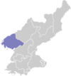
Uiju County
| Ŭiju County 의주군 | |
|---|---|
| County | |
| Korean transcription(s) | |
| • Chosŏn'gŭl | 의주군 |
| • Hancha | 義州郡 |
| • McCune-Reischauer | Ŭiju-gun |
| • Revised Romanization | Uiju-gun |
|
| |
| Country | North Korea |
| Province | North P'yŏngan |
| Administrative divisions | 1 ŭp, 2 workers' districts, 17 ri |
| Area | |
| • Total | 420 km2 (160 sq mi) |
| Population (2008) | |
| • Total | 110,018 |
Ŭiju County is a kun, or county, in North Pyongan Province, North Korea. The county has an area of 420 km², and a population of 110,018 (2008 data).
Geography
Sakchu county and Kusŏng lie to the east; Sŏnch'ŏn and Ch'ŏlsan counties to the south; and Ryongch'ŏn county and Sinŭiju to the west. To the north, Ŭiju shares a border with China.
Administrative Divisions
Ŭiju county is divided into 1 ŭp (town), 2 rodongjagu (workers' districts) and 17 ri (villages):
|
|
Transportation
Ŭiju county is served by the Tŏkhyŏn Line of the Korean State Railway]]. There is also an airport, Uiju Airfield (ICAO airport code: ZKUJ).
1980 earthquake
Ŭiju earthquake was a 5.3 magnitude earthquake that occurred in Ŭiju County in 1980.[1] It is the largest earthquake by magnitude recorded in the Korean Peninsula since South Korea began official earthquake observation in 1978.[2]
See also
References
- ↑ "No One Hurt as Earthquake Rocks Korea". english.chosun.com. Retrieved 2015-09-09.
- ↑ Kim Se-jeong (2015-04-27). "'Korea is not safe from earthquakes'". Korea Times. Retrieved 2015-09-09.
External links
- (Korean) In Korean language online encyclopedias:
Coordinates: 40°11′49″N 124°31′55″E / 40.19694°N 124.53194°E
