Ulley
Coordinates: 53°22′N 1°18′W / 53.37°N 1.30°W
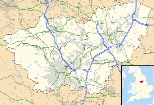
Ulley is a village and civil parish of the Metropolitan Borough of Rotherham in South Yorkshire, England. The population of the civil parish at the 2011 Census was 172.[2] It is located about 4 miles (6 km) south of the town of Rotherham and 7 miles (11 km) east of Sheffield City Centre.
History
Excavations in Ulley have revealed the course of a probable Roman road running north-south through the village.[3] Other Roman finds in the village include coins and a fragment of Samarian ware.[4]
The earliest written record of Ulley is in the Domesday book of 1086, where it is referred to as Ollei. The name is Old English in origin but of uncertain meaning. It may derive from wulf (wolf) or Ulla (a Saxon personal name) and lēah, meaning a meadow.[5] Alternatively, it may mean 'woodland clearing frequented by owls'.[6] Following the Norman conquest of England in 1066, Ulley was among the lands given to the Earl of Mortain. Later, the village passed into the hands of the Priory of Worksop.[7]
During the Second World War, a German bombing raid for Sheffield dropped bombs on a set of cottages situated on Main Street where houses 5–7 are now. The bombs hit the cottages but failed to detonate. When the army arrived to deal with the unexploded bombs, they retired to the pub to decide what to do, and while they were there the bombs exploded, demolishing the cottages.
Governance
Ulley is a civil parish and local issues are governed by a Parish Council, one of 29 such councils in the Metropolitan Borough of Rotherham.[8] It is in the Rother Vale Ward of the Borough, which is represented on the Borough Council by Georgina Boyes, Gerald Nightingale, and John Swift, all members of the Labour Party.[9] This ward is part of the Rother Valley parliamentary constituency, and is represented in the House of Commons by MP Kevin Barron of the Labour Party who has held the seat since 1983.[10]
Demography
At the time of the United Kingdom 2001 Census the population of Ulley civil parish was 183 people.[1]
Below is a table outlining population change of the parish since 1881.
| Year | 1881 | 1901 | 1951 | 2001 | |||||||||
|---|---|---|---|---|---|---|---|---|---|---|---|---|---|
| Population | 136 | 225 | 200 | 183 | |||||||||
| Source: A Vision of Britain through Time[11] | |||||||||||||
Landmarks
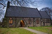
Holy Trinity Church is a Church of England parish church in the village that was built in 1851.[12] It is now run as a benefice with All Saints Church, Aston cum Aughton and Christ Church, Swallownest.
Ulley Country Park is a 19-hectare (47-acre) park a few hundred metres to the west, downhill of the village. The park incorporates Ulley reservoir, which built in 1871 and used to provide approximately 180 million gallons of water per year to Rotherham. By the 1980s, the reservoir was not needed for water supply and was on standby only. It was sold to Rotherham Metropolitan Borough Council for the token sum of £1 and the reservoir and surrounding land were designated a country park.[13] On 25 June 2007, cracks in the reservoir walls were found after heavy rains in the area, causing concerns that the reservoir might burst.[14]
Transport
Ulley is located just off the A618 and close to the M1 motorway. Bus services provided by Powells Bus Co. link the village with Rotherham Town Centre and Maltby.[15] The closest mainline railway stations are at Sheffield, Rotherham Central and Meadowhall.
References and notes
- 1 2 "Ulley CP". Neighbourhood Statistics. Office for National Statistics. Retrieved 16 January 2009.
- ↑ "Civil Parish population 2011". Neighbourhood Statistrics. Office for National Statistics. Retrieved 10 March 2016.
- ↑ "Monument No. 619363". PastScape. English Heritage. Retrieved 18 January 2009.
- ↑ "Ulley". PastScape. English Heritage. Retrieved 18 January 2009.
- ↑ Goodall, Armitage (1914). "Ulley". Place-Names of South-West Yorkshire. Cambridge: Cambridge University Press. p. 289. OCLC 5809268.
- ↑ Mills, A.D. (2003). "Ulley". A Dictionary of English Place-Names. Oxford: Oxford University Press.
- ↑ Rotherham The Unofficial Website
- ↑ "Rotherham Parish and Town Councils". Rotherham Metropolitan Borough Council. Retrieved 18 January 2009.
- ↑ "Ward 11: Rother Vale". Rotherham Metropolitan Borough Council website. Rotherham Metropolitan Borough Council. Retrieved 18 January 2009.
- ↑ "Political profile: Kevin Barron". BBC News: Politics. BBC. 16 October 2002. Retrieved 18 January 2009.
- ↑ "Ulley Tn/CP: Total Population". A Vision of Britain Through Time. Great Britain Historical GIS Project. Retrieved 18 January 2008.
- ↑ "Holy Trinity Church Ulley". Ulleyweb. Ulley Parish Council. Retrieved 19 January 2009.
- ↑ "Ulley Country Park". Rotherham Metropolitan Borough Council website. Rotherham Metropolitan Borough Council. Retrieved 18 January 2009.
- ↑ "Floods force thousands from homes". BBC News. BBC. 26 June 2007. Retrieved 18 January 2009.
- ↑ "Bus timetables for Ulley". Travel South Yorkshire. South Yorkshire Passenger Transport Executive. Retrieved 16 January 2009.
External links
 Media related to Ulley at Wikimedia Commons
- Ulley in the Domesday Book