Umgababa
| Umgababa | |
|---|---|
|
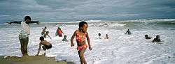
Children on the beach in Umgababa | |
 Umgababa  Umgababa  Umgababa
| |
|
Location within Durban  Umgababa | |
| Coordinates: 30°08′24″S 30°50′10″E / 30.140°S 30.836°ECoordinates: 30°08′24″S 30°50′10″E / 30.140°S 30.836°E | |
| Country | South Africa |
| Province | KwaZulu-Natal |
| Municipality | eThekwini |
| Area[1] | |
| • Total | 2.63 km2 (1.02 sq mi) |
| Population (2001)[1] | |
| • Total | 4,059 |
| • Density | 1,500/km2 (4,000/sq mi) |
| Racial makeup (2001)[1] | |
| • Black African | 99.0% |
| • Coloured | 0.3% |
| • White | 0.7% |
| First languages (2001)[1] | |
| • Zulu | 96.2% |
| • Xhosa | 2.1% |
| PO box | 4126 |
| Area code | 031 |
Umgababa is a rural community area with a large market place for tourists in KwaZulu-Natal, South Africa. It forms part of eThekwini. The uMgababa River (originally "Umkababa", which means "my father's wife") enters the ocean at Umgababa. The name is derived from an ancient feud between the Luthuli tribe who used to live in the valley. Litchis are produced in this region. There once was a large titanium mine here but it closed due to serious sea pollution. In the few years it has grown from rural area into a semi-vacation place, number of people are moving to the lovely place to enjoy the true beauty of nature. The area now hosts the annually biggest year-end event consisting many popular South African musicians on New Year's Eve.
References
- 1 2 3 4 "Main Place Umgababa". Census 2001.