Umm Salal
| Umm Salal أم صلال | |
|---|---|
| Municipality | |
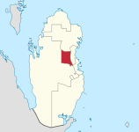 Map of Qatar with Umm Salal highlighted | |
| Coordinates (Umm Salal Mohammed): 25°25′N 51°24′E / 25.42°N 51.40°ECoordinates: 25°25′N 51°24′E / 25.42°N 51.40°E | |
| Country |
|
| Capital | Umm Salal Mohammed |
| Area | |
| • Total | 317.9 km2 (122.7 sq mi) |
| Population (2010)[1] | |
| • Total | 60,509 |
| • Density | 190/km2 (490/sq mi) |
| Time zone | East Africa Time (UTC+03) |
| ISO 3166 code | QA-US |

Umm Salal (Arabic: أم صلال) is a municipality in the State of Qatar.
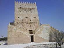
It contains several historic places, such as Barzan Tower. The municipal headquarters Umm Salal is located inland, about 10 km from the coast and 15 km north of Doha, the Qatari capital.
Umm Salal's eastern edge is the shores of the Persian Gulf. On land, it borders the following municipalities:
- Doha - southeast
- Al Rayyan - southwest
- Al Jumaliyah - northwest
- Al Khawr - north
Etymology
The first word of Umm Salal is Arabic for "mother", while salal refers to large rocks or stones. Hence, the area's name translates literally to "mother of rocks". It was so named for the numerous rock formations found in the area.[2]
History
.jpg)
Umm Salal Municipality was established by Law No. 19 in 1972 on the creation of municipalities in Qatar. The Umm Salal Municipality building was inaugurated on 29 of Nov 1974 in the city of Umm Salal, under the High Patronage of the late Sheikh Mohammad bin Jaber Al-Thani, former minister of Municipality and Urban Planning, and with the presence of the late Mr. Abdul Aziz al-Ghanem, head of Shura Council, dignitaries and inhabitants of the region.
Since its creation, the Municipality has been headed by Sheikh Abdullah bin Ahmed Al-Thani. On its creation in 1974 AD, the municipal council of Umm Salal was constituted of: 1- Sheikh Abdullah bin Ahmed Al-Thani, president of the Council. 2- Abdul Aziz bin Nasser al-Atiya, Khraytat region, member. 3- Khamis bin Naser al-Kawari, Umm Salal Mohammad region, member. 4- Saad bin Mansour al-Kaabi, Umm al-Aamad region, member. 5- Mutraf bin Issa al-Hamidi, Umm Qarn region, member. 6- Hamid bin Rashed al-Mohandi, Umm Salal Ali region, member. 7- Majed Jamaan Walid, Municipality secretary and member.
The first departments were Agriculture and Cleanness Departments for three years. Then the Municipality's departments and services were expanded, and were created the Commercial Licenses Department and Food, Health, and building Control Department. The first health inspector was Mr. Nasser Mohammad al-Hajri, in late 1976; he became general secretary in 1978.
Employees at the inauguration were the mayor, a secretary, and four employees for buildings and cleanness.
Historical landmarks
- Barzan Towers in Umm Salal Mohammed.
- Castle of late Sheikh Mohammad bin Jasem Al-Thani.
Area and location
Umm Salal Municipality covers 340 Km2 approximately. It comprises many historical areas, pastures, farms, and cool water wells.
Umm Salal Municipality and its regions are approximately in center-eastern Qatar. Its limits are as follows:
- East by longitude of 230000 approximately.
- West by longitude of 213000 approximately.
- North by latitude of 424000 approximately.
- South by latitude of 404000 approximately.
Zones of the municipality
The following zones were recorded in the 2010 population census:[3]
| Zone | Area (km²) | Population (2010) |
|---|---|---|
| Bu Fasseela Izghawa Al Kharaitiyat Umm Salal Ali Umm Salal Mohammed | 317.9 | 60,509 |
| Municipality | 317.9 | 60,509 |
Demographics
| Historical population | ||
|---|---|---|
| Year | Pop. | ±% |
| 1986[4][5] | 11,161 | — |
| 1997[4][5] | 18,392 | +64.8% |
| 2004[4][5] | 31,547 | +71.5% |
| c-census; e-estimate | ||
The following table is a breakdown of registered live births by nationality and sex for Umm Salal. Places of birth are based on the home municipality of the mother at birth.[6][7]
| Registered live births by nationality and sex | |||||||||
|---|---|---|---|---|---|---|---|---|---|
| Year | Qatari | Non-Qatari | Total | ||||||
| M | F | Total | M | F | Total | M | F | Total | |
| 2001 | 196 | 162 | 358 | 101 | 78 | 179 | 297 | 240 | 537 |
| 2002 | 216 | 179 | 395 | 93 | 73 | 166 | 309 | 252 | 561 |
| 2003 | 215 | 216 | 431 | 89 | 85 | 174 | 304 | 301 | 605 |
| 2004 | 270 | 222 | 492 | 98 | 100 | 198 | 368 | 322 | 690 |
| 2005 | 229 | 270 | 499 | 110 | 95 | 205 | 339 | 365 | 704 |
| 2006 | 275 | 248 | 523 | 96 | 126 | 222 | 371 | 374 | 745 |
| 2007 | 335 | 300 | 635 | 118 | 115 | 233 | 453 | 415 | 868 |
| 2008 | 290 | 279 | 569 | 150 | 168 | 318 | 440 | 447 | 887 |
| 2009 | 345 | 339 | 684 | 146 | 134 | 280 | 491 | 473 | 964 |
Development
Umm Salal and other parts of the Municipality have witnessed increased urban development over the last few years. This development was translated in the increase in issued construction licenses. Two gardens were inaugurated, and the municipality is now working on the creation of a stadium in Umm Salal Ali, and four gardens in various regions of the Municipality. The number of cleanness and sewage workers and vehicles has also been increased to cover the growing demands of citizens. In line with this development, the number of Municipality employees increased, a building for technical affairs was erected, and a new building for health affairs and public affairs is under construction.
References
- ↑ "Census 2010". Qatar Statistics Authority. 2010. Archived from the original on 9 July 2010. Retrieved 2010-07-25.
- ↑ Heba Fahmy (4 April 2015). "What's in a name? The meanings of Qatar districts, explained". Doha News. Retrieved 17 December 2015.
- ↑ "2010 population census" (PDF). Qatar Statistics Authority. Retrieved 13 March 2015.
- 1 2 3 "Population from 1986–2009". Qatar Statistics Authority. Retrieved 28 June 2015.
- 1 2 3 "Population and social statistics". Qatar Statistics Authority. 2004. Retrieved 28 June 2015.
- ↑ "Population statistics". Qatar Information Exchange. Retrieved 15 June 2015.
- ↑ "Qatar Statistics Authority website". Qatar Statistics Authority. Retrieved 28 June 2015.
Capital: Umm Salal Mohammed | |
Census designated areas
|