United States Boundary Commissioner
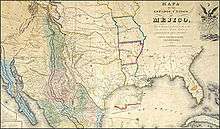
Article V of the TREATY OF PEACE, FRIENDSHIP, LIMITS, AND SETTLEMENT BETWEEN THE UNITED STATES OF AMERICA AND THE UNITED MEXICAN STATES CONCLUDED AT GUADALUPE HIDALGO (known commonly as the Treaty of Guadalupe Hidalgo ) declared that the new boundary between the two republics of the United States and Mexico would lay "three leagues from land, opposite the mouth of the Rio Grande, otherwise called Rio Bravo del Norte, or Opposite the mouth of its deepest branch, if it should have more than one branch emptying directly into the sea; from thence up the middle of that river, following the deepest channel, where it has more than one, to the point where it strikes the southern boundary of New Mexico; thence, westwardly, along the whole southern boundary of New Mexico (which runs north of the town called Paso) to its western termination; thence, northward, along the western line of New Mexico, until it intersects the first branch of the river Gila; (or if it should not intersect any branch of that river, then to the point on the said line nearest to such branch, and thence in a direct line to the same); thence down the middle of the said branch and of the said river, until it empties into the Rio Colorado; thence across the Rio Colorado, following the division line between Upper and Lower California, to the Pacific Ocean. "[1] It delineated the boundary through its text but wasn't written with much knowledge of the area's actually geography; A commissioner and surveyor from each country were appointed to precisely locate landmarks and accurately map the new border, relying on the treaty as their guide.
The 1847 Dirsturnell map accompanied the Treaty of Guadalupe Hidalgo[2] There were discrepancies in the map and in the Spring of 1851 the Commissioners negotiated the Bartlett-García Conde Compromise to end the dispute over where the southern border of New Mexico would be.[3] The Compromise was rejected by the US Senate however, and a new boundary limit had to be negotiated. The Gadsden Purchase and negotiation determined that new boundary.
John Russell Bartlett replaced John C. Frémont as the US Boundary Commissioner on June 15, 1850.[4] The Mexican Commissioner was Gen. Pedro García Conde.
List of US Boundary Commissioners
- 1. Ambrose Sevier 1848 (Died before confirmed by Senate)
- 2. John B. Weller 1849-1850
- 3. John C. Fremont February 1850 appointed but resigned to serve as senator in California
- 4. William H. Emory interim The only of the US Commissioners who had previous experience in "surveying, diplomacy, or organizing and carrying out a major expedition"[5]
- 5. John Russell Bartlett June 1850-
List of US Boundary Surveyors
- Andrew B Gray 1849-
- Lt. Amiel W. Whipple 1851
- Arthur Schott
- James Radziminski
- G. Clinton Gardner
List of Mexican Boundary Commissioners
- Pedro Garcia Conde 1849 - December 1851 (died)
- José Salazar Ylarregui 1851
List of Mexican Surveyors
- José Salazar Ylarregui 1849 - 1851
- Francisco Jiménez 1852-1853
- Agustín Díaz