Unnütze
| Unnütze | |
|---|---|
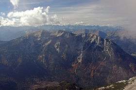 The eastern side of the Unnütze seen from the Guffert (from left: Vorder-, Hoch- and Hinterunnütz) | |
| Highest point | |
| Elevation | 2,078 m (AA) (6,818 ft) |
| Coordinates | 47°30′55″N 11°44′19″E / 47.51528°N 11.73861°ECoordinates: 47°30′55″N 11°44′19″E / 47.51528°N 11.73861°E |
| Geography | |
| Parent range | Brandenberg Alps |
| Climbing | |
| Easiest route | Hotel Scholastika, northern end of the Achensee – Köglalm – Vorderunnütz |
The Unnütze (also called the Unnutze) is a small mountain ridge northeast of the Achensee lake between Achenkirch and Steinberg am Rofan in the Brandenberg Alps in the Austrian state of Tyrol.
The ridge has three summits and runs in a north to south direction. The summits are the Hinterunnütz (2,007 m), the Hochunnütz (2,075 m) and the Vorderunnütz (2,078 m). In general, however, the Vorderunnütz is called the Unnütz.
External links
- tour description (snowshoe tour) (German)
This article is issued from Wikipedia - version of the 12/20/2015. The text is available under the Creative Commons Attribution/Share Alike but additional terms may apply for the media files.