Vermont Route 142
| ||||
|---|---|---|---|---|
| Fort Bridgman Road[1] | ||||
|
Map of Windham County in southeastern Vermont with VT 142 highlighted in red | ||||
| Route information | ||||
| Maintained by VTrans | ||||
| Length: | 10.847 mi[2] (17.457 km) | |||
| Major junctions | ||||
| South end: |
| |||
| North end: |
| |||
| Location | ||||
| Counties: | Windham | |||
| Highway system | ||||
| ||||

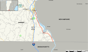
Vermont Route 142 is a north–south state highway in Vermont, United States. It runs from the state border with Massachusetts northward through the town of Vernon to the town of Brattleboro, ending at an intersection with U.S. Route 5.
Route description
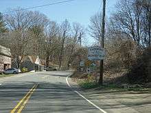
Vermont Route 142 begins at the state border in Vernon, where it continues southbound as Massachusetts Route 142 in the town of Northfield. Route 142 heads north into the town of Vernon, serving the town center before winding north towards Brattleboro. En route to the city, Route 142 parallels Interstate 91 and US-5, which run to the west, and New Hampshire Route 119, which runs just east of the Connecticut River. Route 142 spends its entire length hugging the river, never straying far from its west bank. It runs directly next to the river upon crossing into Brattleboro, proceeding into the heart of the town, where it ends at an intersection with US-5 and Route 119, which begins at the same intersection. Route 119, the second shortest Vermont route at just 0.08-mile (0.13 km) in length (but fully signed nonetheless), crosses the bridge to the east, becoming NH-119 and proceeding south along the east bank of the river, opposite Route 142. US-5 southbound provides access to I-91 at Exit 1, and US-5 northbound provides access to Vermont Route 9 and Vermont Route 30, which intersect less than 0.5 miles (0.8 km) to the north.
Major intersections
The entire route is in Windham County. [2]
| Location[2] | mi[2] | km | Destinations | Notes | |
|---|---|---|---|---|---|
| Vernon | 0.000 | 0.000 | Continuation from Massachusetts | ||
| Brattleboro | 10.838 | 17.442 | Western terminus of VT 119 | ||
| 10.847 | 17.457 | ||||
| 1.000 mi = 1.609 km; 1.000 km = 0.621 mi | |||||
References
- ↑ State of Vermont Board of Libraries (April 28, 2008). "Vermont Named State Highways and Bridges" (PDF). Department of Libraries, State of Vermont. Retrieved April 1, 2015.
- 1 2 3 4 Traffic Research Unit (May 2013). "2012 (Route Log) AADTs for State Highways" (PDF). Policy, Planning and Intermodal Development Division, Vermont Agency of Transportation. Retrieved April 22, 2015.
External links
| Wikimedia Commons has media related to Vermont Route 142. |