Varmahlíð
| Varmahlíð | |
|---|---|
| Village | |
 Location of the Municipality of Skagafjörður | |
 Varmahlíð Location of the Municipality of Skagafjörður | |
| Coordinates: 65°32′N 19°28′W / 65.533°N 19.467°W | |
| Country |
|
| Constituency[1] | Northwest Constituency |
| Region[2] | Northwestern Region |
| Municipality | Skagafjörður |
| Population (January 2011) | |
| • Total | 137 |
| Póstnúmer | 560 |
| Website | Official website |

Varmahlíð is a small village near Skagafjörður in northern Iceland.
Around 140 people live on the eastern slope of the hill for which the town is named (varmur=warm, hlíð=slope).
Varmahlíð is on the ring road Route 1, at the junction of Route 75 leading to Sauðárkrókur, about 24 km to the north. Varmahlíð is in the middle of a flourishing agricultural area, where the Icelandic horse has been treasured for centuries. One of the main industries is horse-rearing. The area has an abundance of geothermal hot water. Hence Varmahlíð has a number of greenhouses with tropical and sub-tropical fruits and vegetables.[3]
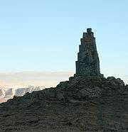
Varmahlið stands high on the western side of a valley, at the crossroads at the foot of Vatnsskarð pass. Near Varmahlíð stands the turf roofed church at Víðimýri, built in 1834, which has a magnificent altarpiece dating from 1727. The monument to Icelandic poet Stephan Stephansson is located at Vatnsskarð pass.
Miðgarður, a concert hall, can be found at Varmahlið. One of Iceland's most famous men's choirs, Karlakórinn Heimir, is based there.
References
- ↑ Political division
- ↑ Mainly statistical division
- ↑ Varmahlíð (Welcome to Varmahlíð)
Coordinates: 65°33′09″N 19°26′42″W / 65.5525°N 19.4449°W