Vermont Route 113
| ||||
|---|---|---|---|---|
|
Map of Orange County in eastern Vermont with VT 113 highlighted in red | ||||
| Route information | ||||
| Maintained by VTrans | ||||
| Length: | 22.847 mi[1] (36.769 km) | |||
| Major junctions | ||||
| West end: |
| |||
|
| ||||
| East end: | East Thetford Road at Lyme, NH | |||
| Location | ||||
| Counties: | Orange | |||
| Highway system | ||||
| ||||

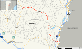
Vermont Route 113 is a state highway in eastern Vermont in the United States. It runs south and east from an intersection with Vermont Route 110 in Chelsea to the New Hampshire border in Thetford. VT 113 crosses the Connecticut River, becoming East Thetford Road, an unnumbered local road in the town of Lyme, New Hampshire which connects to New Hampshire Route 10.
Route description
Route 113 begins in the west at an intersection with Route 110 in the town of Chelsea. Route 113 begins its eastward journey proceeding out of Chelsea, passing into and through the town of Vershire, serving the town center. The highway takes a turn to the south towards the town of Fairlee, where it intersects the western terminus of Route 244. Route 113 is signed as an east–west highway, but at this point is heading due south. It continues southward until crossing into the town of Thetford, where it begins to turn back to the east. Route 113 interchanges with Interstate 91 in the town, at Exit 14. The highway continues to the east, into the village of East Thetford, where it intersects U.S. Route 5 just west of the Connecticut River and the border with New Hampshire. Route 113 briefly overlaps US-5 (for about 30 yards), before turning east to cross the river. Route 113 ends at the bridge crossing, continuing as East Thetford Road in Lyme, New Hampshire, an unnumbered local road which intersects with NH-10 approximately 1 mile (1.6 km) to the east.
Major intersections
The entire route is in Orange County. [1]
| Location[1] | mi[1] | km | Destinations | Notes | |
|---|---|---|---|---|---|
| Chelsea | 0.000 | 0.000 | |||
| Thetford | 14.832 | 23.870 | Western terminus of VT 244 | ||
| 20.969– 21.155 | 33.746– 34.046 | Exit 14 on I-91 | |||
| 22.524 | 36.249 | Western end of concurrency with US 5 | |||
| 22.579 | 36.337 | Eastern end of concurrency with US 5 | |||
| 22.847 | 36.769 | East Thetford Road – Lyme NH | Continuation into New Hampshire | ||
1.000 mi = 1.609 km; 1.000 km = 0.621 mi
| |||||
References
- 1 2 3 4 Traffic Research Unit (May 2013). "2012 (Route Log) AADTs for State Highways" (PDF). Policy, Planning and Intermodal Development Division, Vermont Agency of Transportation. Retrieved April 19, 2015.