Vermont Route 140
| ||||
|---|---|---|---|---|
| Horace Greeley Memorial Highway[1] | ||||
|
Map of Rutland County in western Vermont with VT 140 highlighted in red | ||||
| Route information | ||||
| Length: | 25.059 mi[2][3] (40.329 km) | |||
| Major junctions | ||||
| West end: |
| |||
|
| ||||
| East end: |
| |||
| Location | ||||
| Counties: | Rutland | |||
| Highway system | ||||
| ||||


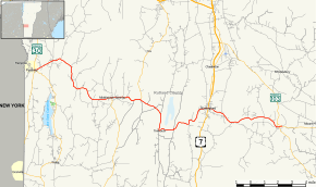
Vermont Route 140 (VT 140) is a 25.059-mile-long (40.329 km) east–west state highway running entirely within Rutland County of western Vermont. The western terminus of the route is at the intersection with Vermont Route 30 in the town of Poultney. Its eastern terminus is at the intersection with Vermont Route 103 in the town of Mount Holly.
Major intersections
The entire route is in Rutland County. [2][3]
| Location[2][3] | mi[2][3] | km | Destinations | Notes | |
|---|---|---|---|---|---|
| Town of Poultney | 0.000 | 0.000 | Western terminus | ||
| Middletown Springs | 8.170 | 13.148 | Western end of concurrency with VT 133 | ||
| Tinmouth | 10.214 | 16.438 | Eastern end of concurrency with VT 133 | ||
| Wallingford | 18.564 | 29.876 | |||
| 24.739 | 39.814 | Western end of concurrency with VT 155 | |||
| 24.826 | 39.954 | Eastern end of concurrency with VT 155 | |||
| Mount Holly | 25.059 | 40.329 | Eastern terminus | ||
1.000 mi = 1.609 km; 1.000 km = 0.621 mi
| |||||
References
- ↑ State of Vermont Board of Libraries (April 28, 2008). "Vermont Named State Highways and Bridges" (PDF). Department of Libraries, State of Vermont. Retrieved January 9, 2016.
- 1 2 3 4 Traffic Research Unit (May 2012). "2011 (Route Log) AADTs for Major Collectors" (PDF). Policy, Planning and Intermodal Development Division, Vermont Agency of Transportation. Retrieved April 22, 2015.
- 1 2 3 4 Traffic Research Unit (May 2013). "2012 (Route Log) AADTs for State Highways" (PDF). Policy, Planning and Intermodal Development Division, Vermont Agency of Transportation. Retrieved April 22, 2015.
External links
This article is issued from Wikipedia - version of the 1/9/2016. The text is available under the Creative Commons Attribution/Share Alike but additional terms may apply for the media files.