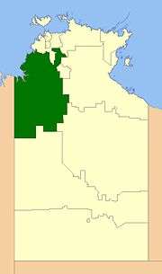
Victoria Daly Region
| Victoria Daly Region Northern Territory | |||||||||||||
|---|---|---|---|---|---|---|---|---|---|---|---|---|---|
 | |||||||||||||
| Population | 6,989 (2013 est)[1] | ||||||||||||
| • Density | 0.0415327/km2 (0.107569/sq mi) | ||||||||||||
| Established | 2008 | ||||||||||||
| Area | 168,277 km2 (64,972.1 sq mi) | ||||||||||||
| Mayor | Betty Sullivan | ||||||||||||
| Council seat | Katherine (outside LGA) | ||||||||||||
| Region | Katherine Region | ||||||||||||
| Territory electorate(s) | Stuart | ||||||||||||
| Federal Division(s) | Lingiari | ||||||||||||
 | |||||||||||||
| Website | Victoria Daly Region | ||||||||||||
| |||||||||||||
The Victoria Daly Region is a local government area of the Northern Territory, Australia. The shire covers an area of 168,277 square kilometres (64,972 sq mi) and has an estimated population of 6,000 people.
History
In October 2006 the Northern Territory Government announced the reform of local government areas. The intention of the reform was to improve and expand the delivery of services to towns and communities across the Northern Territory by establishing eleven new shires. The Victoria Daly Shire was created on 1 July 2008 as were the remaining ten shires. The first election for the Shire was held on 25 October 2008.
A general election was held on 24 March 2012. Councillor Betty Sullivan was elected Mayor of Victoria Daly Shire Council.
The Shire became the Victoria Daly Region on 1 January 2014.
Most of the land now part of the Region used to be unincorporated, but several existing LGAs were merged into it:
- Daguragu Community
- Nauiyu Nambiyu Community
- Nganmarriyanga Community
- Peppimenarti Community
- Timber Creek Community
- Walangeri Ngumpinku Community
- Pine Creek Community
- Thamamurr Community
- Woolianna Community
Wards
The Victoria Daly Regional Council is divided into 5 wards, which is governed by 11 councillors across four wards:
- Pine Creek (1)
- Milngin (1)
- Tyemirri (1)
- Nganmarriyanga (1)
- Thamamurr/Pindi Pindi (4)
- Timber Creek (2)
- Walangeri (1)
- Daguragu (1)
Towns
- Daguragu
- Daly River
- Grove Hill
- Kalkarindji
- Nauiyu Nambiyu
- Palumpa
- Peppimenarti
- Pine Creek
- Timber Creek
- Wadeye
- Woolianna
- Yarralin
References
- ↑ "3218.0 Regional Population Growth, Australia. Table 7. Estimated Resident Population, Local Government Areas, Northern Territory". 3 April 2014. Retrieved 11 September 2014.
External links
Coordinates: 14°28′01″S 132°16′01″E / 14.4670°S 132.2670°E