Vilangan Hills
| Vilangan Hills | |
|---|---|
 Vilangan Hills is a popular picnic spot of Thrissur city residents | |
| Highest point | |
| Elevation | 80 m (260 ft) |
| Naming | |
| Translation | വിലങന് കുന്നു (Malayalam) |
| Geography | |
| Location | Kerala, India |
| Parent range | Independent, adjacent to the Western Ghats |
| Topo map | Laterite hill |
| Geology | |
| Age of rock | Cenozoic, 100 to 80 mya |
| Mountain type | Fault |
| Climbing | |
| Easiest route | Road |
Vilangan Hills (Malayalam: വിലങന് കുന്നു) is a hillock located in Adat Panchayat, near Thrissur city of Kerala state in India. The hill gives a panoramic view of Thrissur city and Thrissur Kole Wetlands from the top. The hill was referred as a Oxygen Jar of Thrissur city.[1][2][3][4][5][6]
Geography
The Vilangan is a laterite hill which has a radius of 8 kilometres. The top of the hill is around 5 acres and the height is 80 metres from the sea level. The hill earlier was a military base and an observation camp during the World War II.[7][8]
Facilities
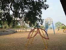
The hill has an open-air theatre, children’s park, Kudumbashree canteen, Vilangan Trekkers Club and Asokavanam Samiti. The hill has a medicinal garden called Asokavanam maintained by Vilangan Trekkers Club and Asokavanam Samiti in association with Department of Tourism (Kerala) and Oushadhi.The foot of the hill opens at the highway near Amala Hospital and the road to the apex of the hill starts from here.[9]The hill remains open from 07.00 AM to 07.00 PM in the evening.[10][11]

References
- ↑ "Vilangan Hills, Thrissur". Mapsofindia.com. Retrieved 2012-06-09.
- ↑ "Places to visit". Indiashotels. Retrieved 2012-06-09.
- ↑ "Attractions". DreamCity. Retrieved 2012-06-09.
- ↑ "Vilangan Hills" (PDF). LuLu. Retrieved 2012-06-09.
- ↑ "Vilangankunnu". DTPC Thrissur. Retrieved 2012-06-09.
- ↑ "THRISSUR, The Cultural Capital". PRD, Kerala. Retrieved 2012-06-09.
- ↑ "Vilangan Trekers Club". Manoramaonline.com. Retrieved 2014-06-05.
- ↑ "Vilangan Kunnu". Thrissur DTPC. Retrieved 2014-06-05.
- ↑ "Asoka saplings planted at Asokavanam in memory of Sukumar Azhikode". Asianetindia. Retrieved 2014-06-05.
- ↑ "Vilangan Trekers Club". Manoramaonline.com. Retrieved 2014-06-05.
- ↑ "Vilangan Kunnu". Thrissur DTPC. Retrieved 2014-06-05.
| Wikimedia Commons has media related to Vilangan Hills. |
Tourist attractions in Thrissur | ||
|---|---|---|
| Dams |  | |
| Beaches and Waterfalls | ||
| Forts and Palaces | ||
| Boatraces | ||
| Parks and Zoos | ||
| Exhibitions and film festivals | ||
| Buildings | ||
| Festivals | ||
| Prehistoric | ||
| Museums | ||
Coordinates: 10°33′26″N 76°10′08″E / 10.5571°N 76.1690°E