Virgin Valley
| Virgin Valley | |
| Valley | |
 view of Mesquite, NV from Virgin Peak, (center of valley) | |
| Country | United States |
|---|---|
| States | Arizona, Nevada |
| Region | Virgin River–Lake Mead ((northeast)-Mojave Desert) |
| Municipalities | Mohave County, Arizona, USA, Clark County, Nevada |
| Borders on | Beaver Dam Mountains & Wilderness-NE Virgin Mountains-E & S Mormon Mesa-SW |
| Cities | Littlefield, Az, Mesquite, NV |
| River | Virgin River |
| Coordinates | 36°48′9″N 114°4′56″W / 36.80250°N 114.08222°WCoordinates: 36°48′9″N 114°4′56″W / 36.80250°N 114.08222°W |
| Lowest point | Riverside (Mohave County, Arizona)-(Virgin River Recreation Area) |
| - location | Virgin Valley (south-west) |
| - elevation | 1,200 ft (366 m) |
| - coordinates | 36°48′9″N 114°4′56″W / 36.80250°N 114.08222°W |
| Length | 25 mi (40 km), SW-NE |
| Width | 12 mi (19 km) |

The Virgin Valley is a valley in northwest Arizona and southeast Nevada on the Virgin River. The Virgin River drains southwest Utah and southeast Nevada; parts of Arizona, especially the Arizona Strip region drain southwards into the Virgin River and Valley.
The Virgin Valley begins as the Virgin River exits the Virgin River Gorge between the Beaver Dam Mountains and Wilderness north, and the northeast of the Virgin Mountains on the south of the Gorge.
Lake Mead on the Virgin River extends slightly upstream into the Virgin Valley.
Description
The Virgin Valley is about 25 miles (40 km) long. Upstream in the valley's northeast, Littlefield, AZ is located at the exit of the Virgin River Gorge, as well as two outfalls from two washes that flow south from the Beaver Dam Mountains. Mesquite, NV is downstream, and on Interstate 15 in Nevada, about 10 miles (16 km). Mesquite is the approximate center of the valley.
The South Virgin Mountains are southeast of the Virgin Valley and Mountains, and separate the northern Overton Arm of Lake Mead from the Colorado River arm. The area north of the South Virgin Mountains is the Mormon Mesa, the southwest border of Virgin Valley. Mormon Mesa is an extension south from the Mormon Mountains which are separated east from the Meadow Valley Wash tributary to north Lake Mead.
The Virgin Valley is vertically bisected, north-south by the Nevada-Arizona border. The downstream Nevada half of the valley has the very beginnings of Lake Mead, about 20 miles (32 km) upstream, where the Virgin River used to flow.
Littlefield, AZ in the valley's northeast[1] is located at 36°54′0″N 113°56′0″W / 36.90000°N 113.93333°W. Mesquite, NV in the valley's center is located at 36°48′9″N 114°4′56″W / 36.80250°N 114.08222°W.
Gallery
 Virgin Peak, southwest Virgin Mountains from Virgin Valley, south of Mesquite
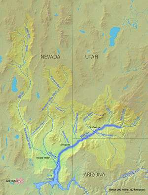 watershed
 valley downstream of Mesquite
References
- ↑ Arizona Road and Recreation Atlas, p. 26-27.
External links
| Wikimedia Commons has media related to Virgin Valley. |
- Beaver Dam Mountains Wilderness Trail, northeast of Virgin Valley
- Riverside, Arizona: Virgin River Recreation Area, southwest Virgin Valley (on Riverside Road)