Virginia State Route 210
| ||||
|---|---|---|---|---|
| Colony Road | ||||
 | ||||
| Route information | ||||
| Maintained by VDOT | ||||
| Length: | 3.14 mi[1] (5.05 km) | |||
| Existed: | c. 1960 – present | |||
| Major junctions | ||||
| West end: |
| |||
|
| ||||
| East end: |
| |||
| Location | ||||
| Counties: | Amherst | |||
| Highway system | ||||
| ||||

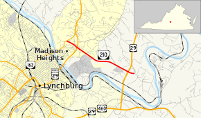
State Route 210 (SR 210) is a primary state highway in the U.S. state of Virginia. Known as Colony Road, the state highway runs 3.14 miles (5.05 km) from SR 163 in Madison Heights east to U.S. Route 29 (US 29) near Madison Heights in southeastern Amherst County.
Route description
SR 210 begins at an intersection with SR 163 (Amherst Highway) in Madison Heights on the opposite side of the James River from Lynchburg. The state highway heads east as a two-lane road until just west of its diamond interchange with US 29 Business (Lynchburg Expressway), where the highway expands to a four-lane divided highway. SR 210's next intersection east of the expressway is with SR 334 (Colony Road). SR 334 is the access road to the Central Virginia Training Center, which was formerly the notorious Virginia State Colony for Epileptics and Feebleminded. SR 210 has no cross traffic until its intersection with SR 672 (Riverview Road) just west of its partial cloverleaf interchange with US 29. The state highway reduces to two lanes at the interchange's southbound ramps and reaches its eastern terminus at the northbound US 29 ramps. The roadway continues east as SR 672 (Riverview Road), which serves the peninsula of land within a bend of the James River.[1][2]
Major intersections
The entire route is in Amherst County.
| Location | mi[1] | km | Destinations | Notes | |
|---|---|---|---|---|---|
| Madison Heights | 0.00 | 0.00 | |||
| 0.54 | 0.87 | Diamond interchange | |||
| 0.73 | 1.17 | ||||
| | 3.14 | 5.05 | interchange | ||
| 1.000 mi = 1.609 km; 1.000 km = 0.621 mi | |||||
References
- 1 2 3 "2010 Traffic Data". Virginia Department of Transportation. 2010. Retrieved 2011-12-06.
- Amherst County (PDF)
- ↑ Google (2011-12-06). "Virginia State Route 210" (Map). Google Maps. Google. Retrieved 2011-12-06.
External links
| < SR 310 | District 3 State Routes 1928–1933 |
SR 312 > |