Vlissingen
| Vlissingen Flushing | |||
|---|---|---|---|
| Municipality | |||
|
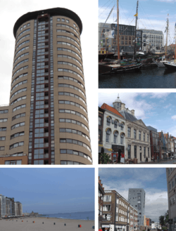
Clockwise from top left: Coastline skyscraper, harbour, museum, residential tower and boulevard with beach | |||
| |||
.svg.png) Location in Zeeland | |||
| Coordinates: 51°27′N 3°34′E / 51.450°N 3.567°ECoordinates: 51°27′N 3°34′E / 51.450°N 3.567°E | |||
| Country | Netherlands | ||
| Province | Zeeland | ||
| Boroughs |
8 Districts
| ||
| Government[1] | |||
| • Body | Municipal council | ||
| • Mayor | Letty Demmers-van der Geest (D66) | ||
| Area[2] | |||
| • Total | 344.83 km2 (133.14 sq mi) | ||
| • Land | 34.18 km2 (13.20 sq mi) | ||
| • Water | 310.65 km2 (119.94 sq mi) | ||
| Elevation[3] | 1 m (3 ft) | ||
| Population (May 2014)[4] | |||
| • Total | 44,353 | ||
| • Density | 1,298/km2 (3,360/sq mi) | ||
| Demonym(s) | Vlissinger | ||
| Time zone | CET (UTC+1) | ||
| • Summer (DST) | CEST (UTC+2) | ||
| Postcode | 4380–4389 | ||
| Area code | 0118 | ||
| Website |
www | ||


Vlissingen (Dutch pronunciation: [ˈvlɪsɪŋə(n)]; Zeelandic: Vlissienge; historical name in English: Flushing) is a municipality and a city in the southwestern Netherlands on the former island of Walcheren. With its strategic location between the Scheldt river and the North Sea, Vlissingen has been an important harbour for centuries. It was granted city rights in 1315. In the 17th century Vlissingen was a main harbour for ships of the Dutch East India Company (VOC). It is also known as the birthplace of Admiral Michiel de Ruyter.
Vlissingen is mainly noted for the yards on the Scheldt where most of the ships of the Royal Netherlands Navy (Koninklijke Marine) are built.
Geography
The municipality of Vlissingen consists of the following places:
- City: Vlissingen
- Villages: Oost-Souburg, Ritthem, and West-Souburg
- Hamlet: Groot-Abeele
History

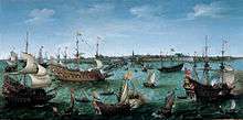
The fishermen’s hamlet that came into existence at the estuary of the Schelde around AD 620 has grown over its 1,400-year history into the third-most important port of the Netherlands. The Counts of Holland, Flanders, and Zeeland had the first harbours dug. Over the centuries, Vlissingen developed into a hub for fishing, especially the herring fishery, commerce, privateering and the slave trade. Under the Treaty of Nonsuch, English garrisons were stationed here and at Brill to keep these ports out of Spanish hands.[5] During the heyday of the Dutch Golden Age, ships from Vlissingen set sail for the various outposts of the Dutch colonial empire and contributed to the world power of The Seven Provinces.
The history of Vlissingen was also marked by invasion, oppression and bombardments. Because of its strategic position at the mouth of the Schelde, the most important passageway to Antwerp, it has attracted the interest, at one time or another, of the British, the French, the Germans and the Spanish. Floods have also been a constant threat. Vlissingen declined during the 18th century. The Napoleonic Wars were particularly disastrous. After 1870, the economy revived after the construction of new docks and the Walcheren canal, the arrival of the railway and the establishment of the shipyard called De Schelde. The Second World War interrupted this growth. The city was heavily damaged by shelling and inundation but was captured and liberated by British Commandos of 4th Special Service Brigade on 3 November 1944.
The city was rebuilt after the war. In the 1960s, the seaport and industrial area of Vlissingen-Oost developed and flourished. Now this area is the economic driving force behind central Zeeland, generating many thousands of jobs. Nowadays approx. 50,000 ships annually from all corners of the world pass through the Schelde. Tourists are attracted to Vlissingen not just because of its history and maritime character, but also because nowhere else in the world do large ships pass this close to shore.[6]
.jpg)
Name
Etymology
The derivation of the name Vlissingen is unclear, though most scholars relate the name to the word fles (bottle) in one way or another.
According to one story, when saint Willibrord landed in Vlissingen with a bottle in the 7th century, he shared its contents with the beggars he found there while trying to convert them. A miracle occurred, familiar to readers of hagiography, when the contents of the bottle did not diminish. When the bishop realised the beggars did not want to listen to his words, he gave them his bottle. After that, he supposedly called the city Flessinghe.
Another source states that the name had its origins in an old ferry-service house, on which a bottle was attached by way of a sign. The monk Jacob van Dreischor, who visited the city in 967, then apparently called the ferry-house het veer aan de Flesse (the ferry at the Bottle). Because many cities in the region later received the appendix -inge, the name, according to this etymology, evolved to Vles-inge.
According to another source, the name was derived from the Danish word Vles, which means tides.
The eastern cape of Novaya Zemlya, Cape Flissingsky was named after the city in 1596 by Willem Barentsz.
Historical English name "Flushing"
Vlissingen was historically called "Flushing" in English. In the 17th century Vlissingen was important enough to be a town that English speakers referred to and that had acquired its own English name. For example, Samuel Pepys referred to the town as "Flushing" in his diaries. In 1673 Sir William Temple referred to Vlissingen as "Flushing" once and "Flussingue" twice in his book about the Netherlands.[7] Some English writers in the Netherlands also used the Dutch name.
Flushing, originally a Dutch colonial village founded in 1645 and now part of Queens, New York City, was first called Vlissingen after the town in the Netherlands. The English settlers who also came to live in the village[8] shortened the name to "Vlissing" by 1657 and then began to call it by its English name "Flushing." The Anglicisation of "Vlissingen" into "Flushing" did not occur after the conquest of New Netherland, but in England well before then. This village was the site of the Flushing Remonstrance.
The village of Flushing in Cornwall was also named after Vlissingen. Originally named Nankersey, the village was given its name by Dutch engineers from Vlissingen in the Netherlands who built the three main quays in the village.
Tourist attractions
- Beeldenhuis (Statuehouse)
- Belgische Loodshuizen (Belgian Maritime Pilotshouses)
- Beursgebouw (Marketbuilding)
- Dokje van Perry (Perry's Dock)
- Fontein ter nagedachtenis aan Elisabeth Wolff en Agatha Deken (Fountain)
- Fort Rammekens
- Garnizoensbakkerij en Kazematten (Garrisonbakery & Casemates
- Gevangentoren (Prisontower)
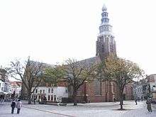
- Grote of Sint-Jacobskerk (Church of St James the Great)
- Het Arsenaal (The Arsenal)
- Hoofdkantoor 'De Schelde' (Headquarter 'De Schelde')
- Koopvaardijmonument (Merchant Navy Monument)
- Lampsinshuis (House of the Lampsins family)
- Leeuwentrap (Lionsstairs)
- Lutherse kerk (Evangelical Lutheran Church)
- Zeevaartschool (Ship transport school)
- Standbeeld Michiel de Ruyter (Michiel de Ruyter Statue)
- NS-Station Vlissingen (Train Station)
- Onze Lieve Vrouwekerk (Church of Our Lady)
- Oranjemolen (The Orange Mill)
- Plein Vier Winden (Square Four Winds)
- Reptielenzoo Iguana (Reptile zoo)
- Sardijntoren (Sardijntower)
- Stadhuis Vlissingen (City Hall)
- Timmerfabriek (Carpentryfactory)
- Watertoren (Water tower)
- Willem III Kazerne (Barracks of William III)
- Windorgel (Windorgan)
- Wooldhuis (Wooldhouse)
- Zeemanserve (Cornelia Quackshofje) (Seaman's quarter)
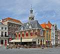 The Marketbuilding at Beursplein (Marketsquare)
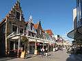 Part of the shoppingstreet Walstraat in 2010
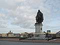 Statue Michiel de Ruyter
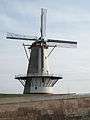 Windmill: de Oranjemolen
 View to a port and a street (de Nieuwendijk)
Topography

Topographic map of Vlissingen (city), Sept. 2014
Climate
Vlissingen has a temperate oceanic climate (Köppen climate classification Cfb) that is milder than the rest of the Netherlands due to its more southern location on the coast.[9] It is approximately 1.5 degrees Celsius warmer annually than Groningen in the northeast. It is also one of the sunniest cities in the Netherlands, receiving approximately 180 more sunshine hours than Maastricht in the southeast.
| Climate data for Vlissingen | |||||||||||||
|---|---|---|---|---|---|---|---|---|---|---|---|---|---|
| Month | Jan | Feb | Mar | Apr | May | Jun | Jul | Aug | Sep | Oct | Nov | Dec | Year |
| Record high °C (°F) | 12.8 (55) |
15.1 (59.2) |
18.6 (65.5) |
26.3 (79.3) |
28.9 (84) |
32.0 (89.6) |
33.3 (91.9) |
33.9 (93) |
29.1 (84.4) |
23.3 (73.9) |
17.0 (62.6) |
14.8 (58.6) |
33.9 (93) |
| Average high °C (°F) | 6.0 (42.8) |
6.2 (43.2) |
9.1 (48.4) |
12.5 (54.5) |
16.4 (61.5) |
19.1 (66.4) |
21.5 (70.7) |
21.6 (70.9) |
18.6 (65.5) |
14.6 (58.3) |
10.1 (50.2) |
6.7 (44.1) |
13.5 (56.3) |
| Daily mean °C (°F) | 4.0 (39.2) |
4.0 (39.2) |
6.4 (43.5) |
9.2 (48.6) |
12.9 (55.2) |
15.6 (60.1) |
18.0 (64.4) |
18.2 (64.8) |
15.8 (60.4) |
12.2 (54) |
8.1 (46.6) |
4.9 (40.8) |
10.8 (51.4) |
| Average low °C (°F) | 2.1 (35.8) |
2.0 (35.6) |
4.1 (39.4) |
6.3 (43.3) |
9.9 (49.8) |
12.6 (54.7) |
15.0 (59) |
15.3 (59.5) |
13.2 (55.8) |
9.8 (49.6) |
6.1 (43) |
3.0 (37.4) |
8.3 (46.9) |
| Record low °C (°F) | −12.1 (10.2) |
−11.1 (12) |
−6.4 (20.5) |
−1.5 (29.3) |
0.8 (33.4) |
5.0 (41) |
9.4 (48.9) |
9.8 (49.6) |
6.7 (44.1) |
−0.1 (31.8) |
−3.8 (25.2) |
−10.6 (12.9) |
−12.1 (10.2) |
| Average precipitation mm (inches) | 58.5 (2.303) |
48.0 (1.89) |
51.1 (2.012) |
38.7 (1.524) |
52.6 (2.071) |
63.2 (2.488) |
64.1 (2.524) |
74.9 (2.949) |
69.4 (2.732) |
76.1 (2.996) |
77.1 (3.035) |
69.0 (2.717) |
742.8 (29.244) |
| Average precipitation days (≥ 1 mm) | 12 | 9 | 11 | 9 | 10 | 10 | 9 | 10 | 11 | 12 | 13 | 13 | 128 |
| Average snowy days | 5 | 5 | 2 | 1 | 0 | 0 | 0 | 0 | 0 | 0 | 2 | 3 | 19 |
| Average relative humidity (%) | 87 | 85 | 83 | 78 | 78 | 78 | 78 | 78 | 80 | 83 | 87 | 88 | 81.9 |
| Mean monthly sunshine hours | 67.8 | 89.2 | 134.2 | 187.2 | 218.3 | 215.5 | 223.2 | 207.4 | 152.9 | 116.5 | 68.7 | 52.1 | 1,733.1 |
| Source #1: Royal Netherlands Meteorological Institute (1981–2010 normals, snowy days normals for 1971–2000)[10] | |||||||||||||
| Source #2: Royal Netherlands Meteorological Institute (1971–2000 extremes)[11] | |||||||||||||
Notable people
A number of Dutch admirals were born in Vlissingen. Among them are Michiel Adriaanszoon de Ruijter, Joost and Adriaen Banckert and the three admirals Cornelis Evertsen. See further People from Vlissingen.
Others:
- Helene Koppejan, astrologer and entrepreneur
Transport
- Railway stations: Vlissingen, Vlissingen Souburg.
- Ferry connection to Breskens, since the Western Scheldt Tunnel was opened on March 2003 for pedestrians and cyclists only.
In popular culture
- Vlissingen is the setting for part of Arthur Ransome's children's adventure novel We Didn't Mean to Go to Sea.
- Vlissingen is also the setting for most of the film The Fourth Man.
References
- ↑ "Burgemeester Letty Demmers-van der Geest" [Mayor Letty Demmers-van der Geest] (in Dutch). Gemeente Vlissingen. Retrieved 22 December 2013.
- ↑ "Kerncijfers wijken en buurten" [Key figures for neighbourhoods]. CBS Statline (in Dutch). CBS. 2 July 2013. Retrieved 12 March 2014.
- ↑ "Postcodetool for 4382MA". Actueel Hoogtebestand Nederland (in Dutch). Het Waterschapshuis. Retrieved 22 December 2013.
- ↑ "Bevolkingsontwikkeling; regio per maand" [Population growth; regions per month]. CBS Statline (in Dutch). CBS. 26 June 2014. Retrieved 24 July 2014.
- ↑ Garrett Mattingly (1959), The Armada, Boston: Houghton Mifflin, Ch. V, "Plans of Operations", p. 44.
- ↑ www.zeegat.nl/
- ↑ Sir William Temple, Observations upon the United Provinces of the Netherlands, ed. Sir George Clark (Oxford: Clarendon Press, 1672), pp. 40, 48 & 116
- ↑ Russell Shorto, The Island at the Centre of the World (Black Swan, 2004) pp. 338-9
- ↑ Climate Summary for Vlissingen, Netherlands
- ↑ "Klimaattabel Vlissingen, langjarige gemiddelden, tijdvak 1981–2010" (PDF) (in Dutch). Royal Netherlands Meteorological Institute. Retrieved 10 September 2013.
- ↑ "Klimaattabel Vlissingen, langjarige extremen, tijdvak 1971–2000" (PDF) (in Dutch). Royal Netherlands Meteorological Institute. Retrieved 10 September 2013.
External links
| Wikisource has the text of the 1911 Encyclopædia Britannica article Flushing (Holland). |
 Media related to Vlissingen at Wikimedia Commons
-
 Vlissingen travel guide from Wikivoyage
 - Official website
 |
Veere | Middelburg | | |
| |
Borsele | |||
| ||||
| | ||||
| Western Scheldt Sluis |
Municipalities of Zeeland | ||
|---|---|---|
 | ||
| ||