Vooremaa
This article is about the region in Estonia. For the newspaper, see Vooremaa (newspaper). For the chess player, see Andres Vooremaa.
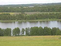
The drumlins and depressions alternating in Raigastvere.
Vooremaa ("Drumlin Land" in Estonian) is a 977 km2 (377 sq mi) landscape region mostly in Jõgeva County, Estonia. It consists of drumlins and depressions that were formed by the glacial accumulation and erosion. All the landscape elements such as relief, vegetation, waterbodies and watercourses as well as settlements follow the northwest-southeast direction of the drumlins. The drumlins are 2–13 km (1.2–8.1 mi) long, 1–2 km (0.62–1.24 mi) wide and up to 70 m (230 ft) high.[1] 47% of Vooremaa is cultivated and villages are located on the feet of the drumlins. One fifth (20.3%) of the area is covered by wetlands. The highest point is Laiuse drumlin, at 144 m (472 ft).
References
- ↑ "Vooremaa drumlin field". Eesti Maaturism MTÜ. Retrieved 11 August 2012.
This article is issued from Wikipedia - version of the 9/26/2015. The text is available under the Creative Commons Attribution/Share Alike but additional terms may apply for the media files.