Vrigny, Orne
| Vrigny | |
|---|---|
|
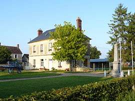
Vrigny primary school and war memorial | |
 Vrigny | |
|
Location within Normandy region  Vrigny | |
| Coordinates: 48°40′20″N 0°01′09″W / 48.6722°N 0.0192°WCoordinates: 48°40′20″N 0°01′09″W / 48.6722°N 0.0192°W | |
| Country | France |
| Region | Normandy |
| Department | Orne |
| Arrondissement | Argentan |
| Canton | Mortrée |
| Intercommunality | Communauté de communes du Pays de Mortrée |
| Government | |
| • Mayor (2008–2014) | Marcel Travert |
| Area1 | 13.45 km2 (5.19 sq mi) |
| Population (2006)2 | 335 |
| • Density | 25/km2 (65/sq mi) |
| Time zone | CET (UTC+1) |
| • Summer (DST) | CEST (UTC+2) |
| INSEE/Postal code | 61511 / 61570 |
| Elevation |
157–268 m (515–879 ft) (avg. 273 m or 896 ft) |
|
1 French Land Register data, which excludes lakes, ponds, glaciers > 1 km² (0.386 sq mi or 247 acres) and river estuaries. 2 Population without double counting: residents of multiple communes (e.g., students and military personnel) only counted once. | |
Vrigny is a former commune in the Orne department in north-western France. In 2015 it became part of Boischampré.
See also
References
| Wikimedia Commons has media related to Vrigny (Orne). |
This article is issued from Wikipedia - version of the 9/10/2016. The text is available under the Creative Commons Attribution/Share Alike but additional terms may apply for the media files.