Stege and Waidbach
| Waidbach | |
| River | |
| Country | Germany |
|---|---|
| Land | Mecklenburg-Vorpommern |
| Source | |
| - location | bridge between Konow and Wilsen |
| - elevation | 24 m (79 ft) |
| - coordinates | 54°03′33″N 11°59′33″E / 54.0593°N 11.9925°E |
| Mouth | River Beke |
| - elevation | 3 m (10 ft) |
| - coordinates | 53°58′36″N 12°00′46″E / 53.9768°N 12.0129°ECoordinates: 53°58′36″N 12°00′46″E / 53.9768°N 12.0129°E |
Stege and Waidbach are two small rivers in Mecklenburg-Vorpommern, Germany, forming a pseudobifurcation. This means, they are linked by a waterbody that is drained in both directions. The common top section is fed by sources in small valleys at the eastern slope of Kühlung hills.
| Stege River | |
| Code | DE/9638 (together with lower section of Mühlenfließ), 963812 (top section), 96388 (old branch) |
| Country Federal state | Deutschland Mecklenburg-Vorpommern |
| Towns | Bad Doberan |
| Basin | originally own, now Mühlenfließ |
| Source - location - elevation -coordinates | Dänenberg (eastern part of Kühlung 76 m 54°03′15″N 11°56′59″E / 54.05417°N 11.94972°E |
| Mouth - location & coordinates -elevation | originally near Heiligendamm 53°58′36″N 11°52′08″E / 53.97667°N 11.86889°E now in Bad Doberan 54°06′58″N 11°55′00″E / 54.11611°N 11.91667°E 0 m |
| Length | hydrologically 21 km, nominally 5.3 – 14.7 km |
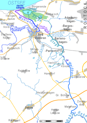
Mühlenfließ, Stege and Waidbach
dark lilac = pseudobifurkation
lilac = canal built in 1968
green area = below sea level
dark lilac = pseudobifurkation
lilac = canal built in 1968
green area = below sea level
See also
This article is issued from Wikipedia - version of the 8/10/2016. The text is available under the Creative Commons Attribution/Share Alike but additional terms may apply for the media files.