Wainfleet St Mary
| Wainfleet St Mary | |
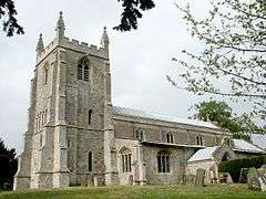 Wainfleet St Mary Church |
|
 Wainfleet St Mary |
|
| Population | 1,025 (2011) |
|---|---|
| OS grid reference | TF469591 |
| – London | 110 mi (180 km) S |
| Civil parish | Skegness |
| District | East Lindsey |
| Shire county | Lincolnshire |
| Region | East Midlands |
| Country | England |
| Sovereign state | United Kingdom |
| Post town | Skegness |
| Postcode district | PE24 |
| Dialling code | 01754 |
| Police | Lincolnshire |
| Fire | Lincolnshire |
| Ambulance | East Midlands |
| EU Parliament | East Midlands |
| UK Parliament | Boston and Skegness |
|
|
Coordinates: 53°06′33″N 0°11′36″E / 53.109278°N 0.193211°E
Wainfleet St Mary is a village and civil parish in the East Lindsey district of Lincolnshire, England. It is situated directly south of Wainfleet All Saints on the A52 road, 5 miles (8 km) south-west from Skegness and 14 miles (23 km) north-east from Boston. The 2001 Census recorded a population of 1,106,[1] reducing to 1,025 at the 2011 census.[2] It includes the hamlet of Wainfleet Bank.[3]
History
The first mention of Wainfleet St Mary as a separate and distinct place from Wainfleet All Saints, is in 1378 when it belonged to the Priory of Stixwould.[4]
The limestone Grade II listed church is dedicated to Saint Mary and dates from the 12th century, being restored in 1875 and 1892.[5] The western tower dates from the 12th century although it was raised in the 15th century. Inside is a 15th-century font and a black and white marble monument, with broken pediment, to Edward Barkham who died in 1724. Ten yards (9 m) south of the nave is the remains of a 14th-century stone cross, which is both a scheduled monument and Grade II listed.[6]
There is a Grade II listed windmill at Mill Garage built of red brick in the early 19th century. It ceased working in 1947 and has been converted into a house.[7][8]
Within the garden of Pinfold Lodge, lying at the junction of Vicarage Road and Low Road, is a brick-built octagonal pinfold roofed with slate. It is Grade II listed and thought to date back to approximately 1800.[9][10]
Wainfleet St Mary C of E Primary School originated in the Bethlehem Hospital School, built in 1831. It was known as Wainfleet St Mary Church School by 1903, and as Wainfleet St Mary C of E School by 1913 and until 1981. The school was closed in 1987.[11]
Population
| Population of Wainfleet St Mary Civil Parish | ||||||||||||||
|---|---|---|---|---|---|---|---|---|---|---|---|---|---|---|
| Year | 1801 | 1811 | 1821 | 1831 | 1841 | 1851 | 1881 | 1891 | 1901 | 1911 | 1921 | 1931 | 1961 | 2001 |
| Population[12] | 421 | 475 | 544 | 660 | 731 | 717 | 705 | 718 | 669 | 789 | 908 | 958 | 1,038 | 1,106 |
Geography
 |
Thorpe St Peter, Firsby, Spilsby | Burgh Le Marsh, Orby, Alford | Wainfleet All Saints, Croft, Skegness | |
| Midville, Stickney, Coningsby | |
Gibraltar Point | ||
| ||||
| | ||||
| Friskney, Wrangle, Boston |
References
- ↑ "Neighbourhood Statistics". Office for National Statistics. Retrieved 1 May 2011.
- ↑ "Civil Parish population 2011". Neighbourhood Statistics. Office for National Statistics. Retrieved 2 June 2016.
- ↑ "Wainfleet St Mary". Genuki. Retrieved 1 May 2011.
- ↑ Edmund Oldfield. A topgraphical and historical account of wainfleet and the wapentake of candleshoe in the county of Lincoln. Longman, Rees, Orme, Brown and Green. p. 73/4. Retrieved 1 May 2011.
- ↑ "British Listed Buildings". British Listed Buildings. Retrieved 1 May 2011.
- ↑ "British Listed Buildings". British Listed Buildings. Retrieved 1 May 2011.
- ↑ "Windmill". National Heritage List for England. English Heritage. Retrieved 26 August 2011.
- ↑ Historic England. "Windmill (498480)". PastScape. Retrieved 26 August 2011.
- ↑ "Horse engine". National Heritage List for England. English Heritage. Retrieved 26 August 2011.
- ↑ Historic England. "Pinfold (1432443)". PastScape. Retrieved 26 August 2011.
- ↑ "Wainfleet St Mary CE Primary School". Lincs to the Past. Lincolnshire Archives. Retrieved 26 August 2011.
- ↑ "Vision of Britain". Retrieved 25 August 2011.
External links
 Media related to Wainfleet St Mary at Wikimedia Commons
England Portal | |
| Unitary authorities | |
| Boroughs or districts | |
| Major settlements |
|
| Topics | |