Wallerawang
Wallerawang is a small township in the Central Tablelands of New South Wales, Australia. It is located approximately 14 km northwest of Lithgow adjacent to the Great Western Highway from Sydney. It is also located on the Main Western railway line at the junction of the Gwabegar line.
History
The original inhabitants of the area west of the Blue Mountains were the Wiradjuri Aboriginal Australians. It is believed they knew the area as Waller-owang. It is understood to mean place near wood and water, or plenty of water.[1]
James Blackman was probably the first European to discover the area when he marked out the route of the new road from Bathurst to the area now known as Wallerawang.
In 1824, 11 years after the first exploration led by Blaxland over the Blue Mountains, a James Walker was granted a large portion of land in the area now known as Wallerawang. In 1836 the property was to become known as Barton Park.
Two of Walker's convict servants took up land leases in the area in the 1850s, one of them was Maddox who named his lease Lidsdale.
Charles Darwin, the English naturalist, stayed at "Wallerowang House" (later to become Barton Park) in 1836. In the book, Darwin describes the countryside around the Wallerawang area and the wildlife including Platypus in his book "The Voyage of the Beagle".[2]
The local school has operated at three sites, in 1860 the first small stone school opened near the present power station, in 1882 the school relocated nearer the township and finally to its present location near Lake Wallace in 1995. The 1860 school, which is still standing, was opened by James Walker's widow.
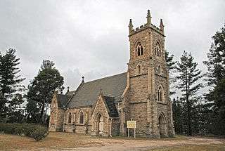
The Church of St John the Evangelist, built 1881, was financed by private funding.[3] It was designed by architect Edmund Blacket, and is listed by the NSW Heritage Council. [4]
The Great Western Railway passes through the town of Wallerawang. In 1870 the track was opened to Wallerawang on its way to the next temporary terminus of Tarana in 1872.
Railway
The railway station opened in 1870[5] and closed during the early 1990s.
Wallerawang Power Station

- The Wallerawang Power Station was a coal fired station located on the eastern side of the township.
- In 1951 the Electricity Commission of New South Wales commenced construction of the power station, power being generated in 1957.
- In 1978 Lake Wallace was constructed to provide additional water cooling capacity for the power station.
- With various upgrades the station generated power for the Australian national power grid.[6]
- It was placed out of service in 2014[7] and is marked for demolition.[8]
References
- ↑ "Wallerawang". Newspaper. Sydney Morning Herald. 1 Jan 2009. Retrieved 8 November 2012.
- ↑ "Wallerawang History". Website. Lithgow Tourism. 2011-08-19. Retrieved 8 November 2012.
- ↑ Illustrated Sydney News 26 Nov 1881 p.3
- ↑ Heritage Council
- ↑ Wallerawang station NSWrail.net, accessed 14 April 2010.
- ↑ Wallerawang Lithgow Visitor Information Centre, accessed 14 April 2010.
- ↑ EnergyAustralia to close Wallerawang Power Station
- ↑ Wallerawang Power Station to be demolished
| Preceding station | NSW Main lines | Following station | ||
|---|---|---|---|---|
towards Bourke | Main Western Line | towards Sydney |
||
| Preceding station | NSW Branch lines | Following station | ||
Pipers Flat towards Gwabegar | Gwabegar Line | Terminus |
Coordinates: 33°24′40″S 150°03′50″E / 33.411°S 150.064°E