Walthamstow Queen's Road railway station
| Walthamstow Queen's Road | |
|---|---|
 | |
 Walthamstow Queen's Road Location of Walthamstow Queen's Road in Greater London | |
| Location | Walthamstow |
| Local authority | London Borough of Waltham Forest |
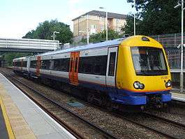
| Managed by | London Overground |
| Owner | Network Rail |
| Station code | WMW |
| DfT category | E |
| Number of platforms | 2 |
| Accessible | Yes [1] |
| Fare zone | 3 |
| OSI |
Walthamstow Central |
| National Rail annual entry and exit | |
| 2009–10 |
|
| 2010–11 |
|
| 2011–12 |
|
| 2012–13 |
|
| 2013–14 |
|
| 2014–15 |
|
| Key dates | |
| 1894 | Opened |
| Other information | |
| Lists of stations | |
| External links | |
| WGS84 | 51°34′54″N 0°01′26″W / 51.5817°N 0.024°WCoordinates: 51°34′54″N 0°01′26″W / 51.5817°N 0.024°W |
|
| |
Walthamstow Queen's Road railway station is a London Overground station between Blackhorse Road and Leyton Midland Road stations on the Gospel Oak to Barking Line in northeast London. It is in Zone 3. It opened as "Walthamstow" on 9 July 1894 and was renamed on 6 May 1968[4][5] under British Rail. The station stands on Edinburgh Road (not Queens Road). There is step-free access from the street to both platforms.
The station is about 330 yards (300 m) from Walthamstow Central station and there is a direct footpath link between the two stations via a new exit onto Exeter Road. The footpath link, which opened in August 2014, is called Ray Dudley Way in commemoration of a local man who campaigned for the link for many years.[6]
The station is served by a train every 15 minutes in both directions throughout the day, though from June 2016 until February 2017 the service is suspended (with a rail-replacement bus in operation) whist the line undergoes major rebuilding work associated with forthcoming electrification.[7]
References
- ↑ "London and South East" (PDF). National Rail. September 2006. Archived from the original (PDF) on 6 March 2009.
- ↑ "Out of Station Interchanges" (XLS). Transport for London. May 2011. Archived from the original on 20 October 2012.
- 1 2 3 4 5 6 "Station usage estimates". Rail statistics. Office of Rail Regulation. Please note: Some methodology may vary year on year.
- ↑ Forgotten Stations of Greater London by J.E.Connor and B.Halford
- ↑ Chronology of London Railways by H.V.Borley
- ↑ "Ray Dudley Way pedestrian footpath opened on Monday". The Bolton News. 13 August 2014. Retrieved 28 August 2014.
- ↑ Table 62 National Rail timetable, May 2016
External links
| Wikimedia Commons has media related to Walthamstow Queen's Road railway station. |
- Train times and station information for Walthamstow Queen's Road railway station from National Rail
| Preceding station | Following station | |||
|---|---|---|---|---|
towards Gospel Oak | Gospel Oak to Barking Line | towards Barking |
||
| Disused Railways | ||||
| Blackhorse Road | Tottenham and Forest Gate Railway | Leyton Midland Road | ||
| |||||||||||||||||||||||||||||||||
| |||||||||||||||||||||||||||||||||