Warm Springs River
| Warm Springs River | |
| Country | United States |
|---|---|
| State | Oregon |
| County | Wasco[1] |
| Source | Cascade Range |
| - location | north of Olallie Butte |
| - elevation | 4,069 ft (1,240 m) [2] |
| - coordinates | 44°57′39″N 121°47′21″W / 44.96083°N 121.78917°W [1] |
| Mouth | Deschutes River |
| - elevation | 1,240 ft (378 m) [1] |
| - coordinates | 44°51′28″N 121°04′09″W / 44.85778°N 121.06917°WCoordinates: 44°51′28″N 121°04′09″W / 44.85778°N 121.06917°W [1] |
| Length | 30 mi (48 km) |
| Basin | 107 sq mi (277 km2) |
| Discharge | for 2.5 miles (4.0 km) east of Kah-Nee-Ta, river mile 4.6 (7.4 km upstream from mouth) |
| - average | 432 cu ft/s (12 m3/s) [3] |
| - max | 22,600 cu ft/s (640 m3/s) |
| - min | 149 cu ft/s (4 m3/s) |
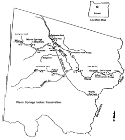 Map of the Warm Springs River basin | |
The Warm Springs River is a tributary of the Deschutes River in north-central Oregon in the United States.[1] It flows generally southeast along the east side of the Cascade Range. The watershed is approximately between Mount Jefferson and Timothy Lake, and the northwestern and southwestern boundaries of the Warm Springs Indian Reservation coincide with the watershed. The headwaters are less than 1⁄4 mile (0.40 km) from the Wasco County–Clackamas County boundary (which follows the Cascade crest). The river flows generally eastward, with occasional diagonals southeast or northeast. It joins the Deschutes River at river mile 83.7 (134.7 km upstream from the mouth of the Deschutes).
Named tributaries of the river from source to mouth are Dry and Bunchgrass creeks followed by the South Fork Warm Springs River. Then come Badger, Mill, and Beaver creeks.[4]
See also
References
- 1 2 3 4 5 "Warm Springs River". Geographic Names Information System. United States Geological Survey. November 28, 1980. Retrieved December 14, 2014.
- ↑ Source elevation derived from Google Earth search using GNIS source coordinates.
- ↑ "Water-Data Report 2013: 14097100 Warm Springs River Near Kahneeta Hot Springs, OR" (PDF). U.S. Geological Survey. Retrieved December 13, 2014. The average, maximum, and minimum values are based on flows recorded during water years 1973 to 2013.
- ↑ "United States Topographic Map". United States Geological Survey. Retrieved January 28, 2016 – via Acme Mapper. The map includes mile markers along the lower 20 miles (32 km) of the Warm Springs River and along the Deschutes River.
External links
- "Instream Flow Study of the Warm Springs River" (PDF) from the Bonneville Power Administration, published in September 1981