Washington Pass
For the pass in New Mexico formerly known as Washington Pass, see Narbona Pass.
| Washington Pass | |
|---|---|
|
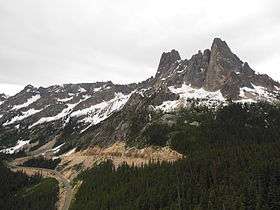
State Route 20 and Liberty Bell Mountain at the pass, as seen from Washington Pass Overlook Trail | |
| Elevation | 5,477 ft (1,669 m) |
| Traversed by | State Route 20 |
| Location | Chelan / Okanogan counties, Washington, United States |
| Range | Cascades |
| Coordinates | 48°31.4′N 120°39.3′W / 48.5233°N 120.6550°W |
| Rainy Pass | |
|---|---|
|
Rainy Pass in spring | |
| Elevation | 4,875 ft (1,486 m) |
| Traversed by | State Route 20 |
| Location | Chelan / Skagit counties, Washington, United States |
| Range | Cascades |
| Coordinates | 48°31.1′N 120°44.1′W / 48.5183°N 120.7350°W |
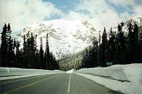
Washington Pass (el. 5477 ft./1669 m.) and Rainy Pass (el. 4875 ft./1486 m.) are two mountain passes on State Route 20 (North Cascades Highway) in the North Cascades mountains of Washington State. Rainy Pass is about 4 miles to the west of Washington Pass. The passes are typically closed between November and April due to heavy snowfall.
The north-south Pacific Crest Trail crosses east-west Highway 20 at Rainy Pass. The Washington Pass Overlook Trail, designated a National Recreation Trail in 1978, runs a short 0.2 miles (0.32 km) from the pass to an overlook with views of Liberty Bell Mountain and the highway 700 feet (210 m) below.[1]
References
- ↑ "Washington Pass Overlook Trail". American Trails. 2013-04-24. Retrieved 2014-08-14.
External links
- U.S. Geological Survey Geographic Names Information System: Washington Pass—Washington Pass
- U.S. Geological Survey Geographic Names Information System: Rainy Pass—Rainy Pass
- Pass road conditions from WSDOT
Coordinates: 48°31.4′N 120°39.3′W / 48.5233°N 120.6550°W
This article is issued from Wikipedia - version of the 2/11/2015. The text is available under the Creative Commons Attribution/Share Alike but additional terms may apply for the media files.