Washington State Route 122
| ||||
|---|---|---|---|---|
|
SR 122 is highlighted in red. | ||||
| Route information | ||||
| Auxiliary route of US 12 | ||||
| Defined by RCW 47.17.227 | ||||
| Maintained by WSDOT | ||||
| Length: | 7.88 mi[1] (12.68 km) | |||
| Existed: | 1991[2] – present | |||
| Major junctions | ||||
| West end: |
| |||
| East end: |
| |||
| Location | ||||
| Counties: | Lewis | |||
| Highway system | ||||
| ||||

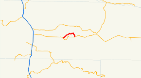
State Route 122 (SR 122) is a 7.88-mile-long (12.68 km) state highway on the north shore of Lake Mayfield in rural Lewis County, located within the U.S. state of Washington. The highway begins at U.S. Route 12 (US 12) in Silver Creek and travels east through Ike Kinswa State Park before turning south over the Cowlitz River to Mossyrock, ending at US 12. SR 122 was established in 1991 on roads built in the 1910s and 1940s and the designation was transferred from SR 142.
Route description
SR 122 begins as Silver Creek Road at an intersection with US 12 in the unincorporated community of Silver Creek in rural Lewis County.[3] The highway travels northeast over Silver Creek towards Mayfield Lake, becoming Harmony Road.[4][5] SR 122 continues east along the north shore of the lake and crosses the Tilton River before passing through Ike Kinswa State Park.[6][7][8] The highway continues east to Harmony,[9] where it turns south to cross the Cowlitz River,[10] eventually ending at an intersection with US 12 north of Mossyrock.[11][12]
Every year, the Washington State Department of Transportation (WSDOT) conducts a series of surveys on its highways in the state to measure traffic volume. This is expressed in terms of average annual daily traffic (AADT), which is a measure of traffic volume for any average day of the year. In 2011, WSDOT calculated that between 850 and 1,100 vehicles per day used the highway, mostly at the US 12 intersection in Mossyrock.[13]
History
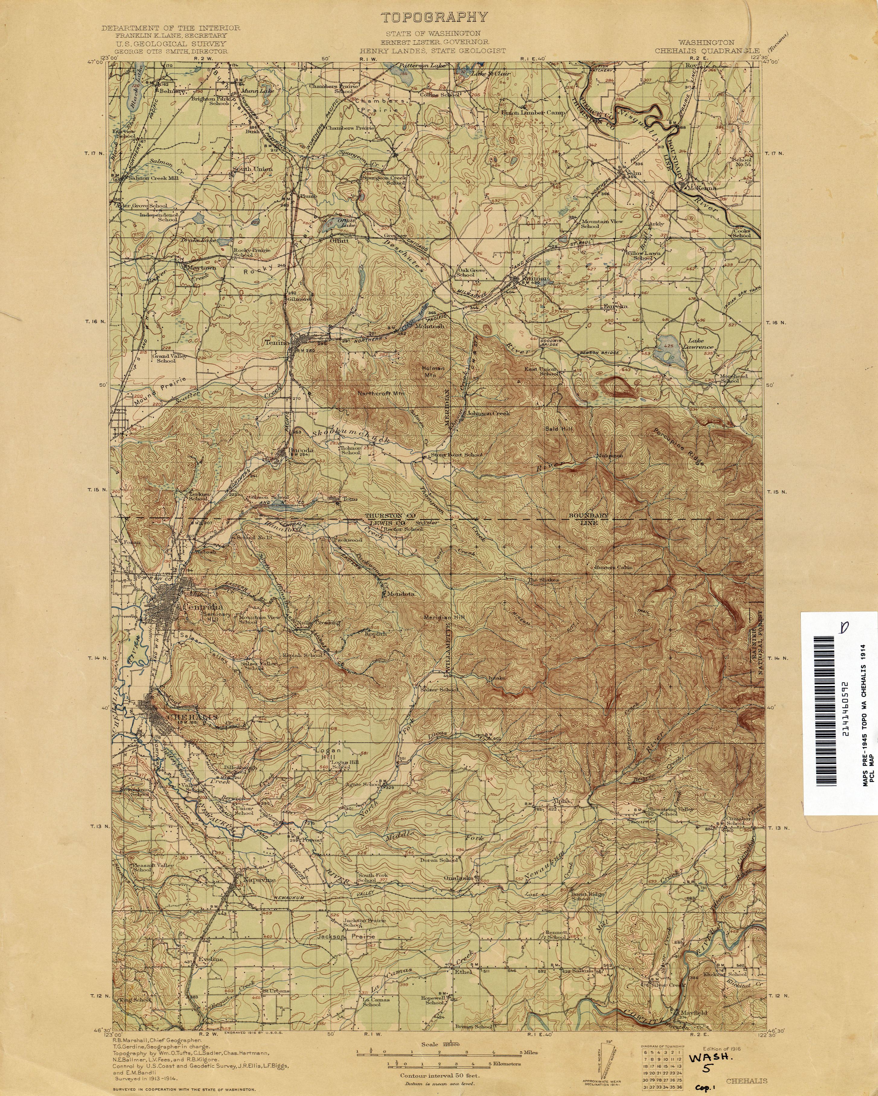
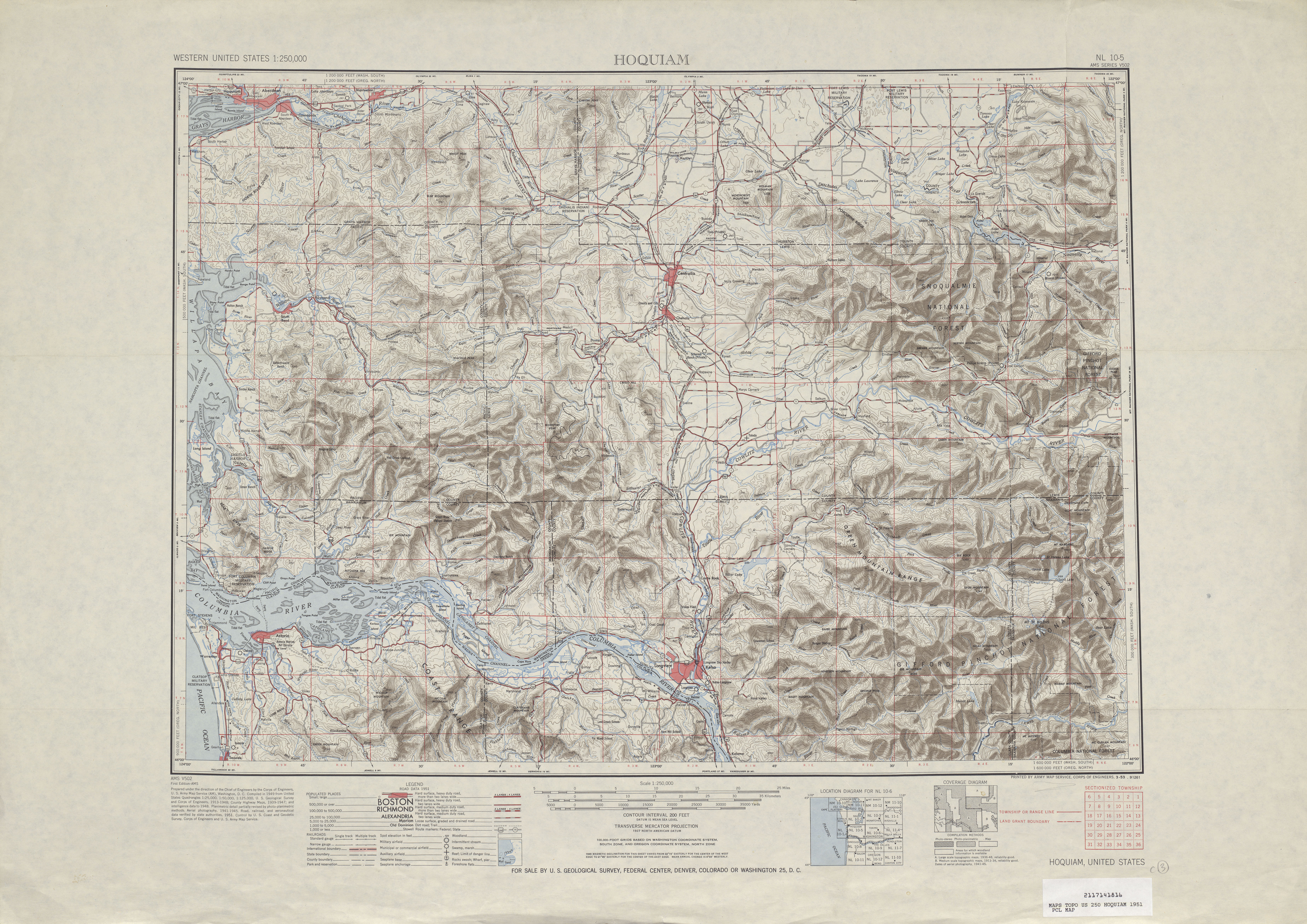
SR 122 between Silver Creek and Harmony follows the route of an unpaved road built in the 1910s and removed after the completion of the Mayfield Dam in 1963,[14][15] while the road from Harmony to Mossyrock was built in the 1940s.[16] The roadway was later reconstructed and designated as SR 122, previously used on the route of SR 142 until 1967, in 1991.[2]
Major intersections
The entire highway is in Lewis County.
| Location | mi[1] | km | Destinations | Notes | |
|---|---|---|---|---|---|
| Silver Creek | 0.00 | 0.00 | Western terminus | ||
| Mossyrock | 7.88 | 12.68 | Eastern terminus, continues as Williams Street | ||
| 1.000 mi = 1.609 km; 1.000 km = 0.621 mi | |||||
References
- 1 2 Staff (2012), State Highway Log: Planning Report 2011, SR 2 to SR 971 (PDF), Washington State Department of Transportation, pp. 1037–1038, retrieved January 30, 2013
- 1 2 "47.17.227: State route No. 122", Revised Code of Washington, Washington State Legislature, 1991, retrieved January 30, 2013
- ↑ "Feature Detail Report for: Silver Creek (Populated Place)", Geographic Names Information System, United States Geological Survey, September 10, 1979, retrieved January 30, 2013
- ↑ "Feature Detail Report for: Silver Creek (Stream)", Geographic Names Information System, United States Geological Survey, September 10, 1979, retrieved January 30, 2013
- ↑ "Feature Detail Report for: Mayfield Lake", Geographic Names Information System, United States Geological Survey, December 31, 1992, retrieved January 30, 2013
- ↑ "Feature Detail Report for: Ike Kinswa State Park", Geographic Names Information System, United States Geological Survey, July 1, 1990, retrieved January 30, 2013
- ↑ Ike Kinswa State Park (PDF) (Map). Washington State Parks. November 9, 2010. Retrieved January 30, 2013.
- ↑ "Feature Detail Report for: Tilton River", Geographic Names Information System, United States Geological Survey, September 10, 1979, retrieved January 30, 2013
- ↑ "Feature Detail Report for: Harmony", Geographic Names Information System, United States Geological Survey, September 10, 1979, retrieved January 30, 2013
- ↑ "Feature Detail Report for: Cowlitz River", Geographic Names Information System, United States Geological Survey, September 10, 1979, retrieved January 30, 2013
- ↑ "Feature Detail Report for: Mossyrock", Geographic Names Information System, United States Geological Survey, September 10, 1979, retrieved January 30, 2013
- ↑ Google (January 2, 2011). "State Route 122" (Map). Google Maps. Google. Retrieved January 2, 2011.
- ↑ Staff (2011), 2011 Annual Traffic Report (PDF), Washington State Department of Transportation, p. 140, retrieved January 30, 2013
- ↑ Washington: Chehalis Quadrangle (JPG) (Map). 1:125,000. United States Geological Survey. 1916. Retrieved January 30, 2013.
- ↑ Cowlitz River Project - Statistics, Tacoma Public Utilities, retrieved January 30, 2013
- ↑ Hoquiam, 1951 (JPG) (Map). 1:250,000. United States Geological Survey. 1951. Retrieved January 30, 2013.