Washita River
| Washita River | |
|---|---|
|
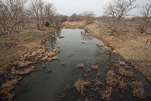
Upper Washita River in Hemphill County, Texas | |
|
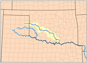
Map of the Washita River watershed | |
| Other name(s) | Ouachita, False Washita |
| Country | United States |
| Basin | |
| Main source |
Roberts County, Texas 3,028 ft (923 m) 35°37′32″N 100°35′46″W / 35.6256003°N 100.5962467°W[1] |
| River mouth |
Lake Texoma 617 ft (188 m) 33°54′42″N 96°34′41″W / 33.9117669°N 96.5780504°WCoordinates: 33°54′42″N 96°34′41″W / 33.9117669°N 96.5780504°W[1] |
| River system | Red River |
| Basin size | 7,870 sq mi (20,400 km2) |
| Physical characteristics | |
| Length | 295 mi (475 km) |
The Washita River is a river in Texas and Oklahoma, United States. The river is 295 miles (475 km) long and terminates into Lake Texoma in Johnston County (also Bryan County and Marshall County - 33°55′N 96°35′W / 33.917°N 96.583°W), Oklahoma and the Red River.
Geography
The Washita River crosses Hemphill County, Texas and enters Oklahoma in Roger Mills County. In Oklahoma it cuts through the Oklahoma Counties of: Roger Mills, Custer, Washita, Caddo, Grady, Garvin, Murray, Carter, and Johnston. Lake Texoma is the border between Bryan County and Marshall County.
The river bisects the heart of the Anadarko Basin, according to the USGS the Anadarko Basin is the fifth largest natural gas formation area discovered in the United States.
When the river reaches the Arbuckle Mountains it drops 30 ft/mile as it cuts through Big Canyon, a limestone gorge 300 feet deep.
The Washita's river bed is made up of unstable mud and sand. The banks of the river are steeply incised and erosive, made up of red earth. This makes it one of the most silt-laden streams in North America. [2]
Sources
The Washita River forms in eastern Roberts County, Texas (35°38′N 100°36′W / 35.633°N 100.600°W) near the town of Miami, Texas in the Texas Panhandle.
Tributaries
Along its path, the Foss Dam impounds the Washita River to create the huge Foss Reservoir. Several reservoirs along the Washita River valley hold the waters of small tributaries, including Fort Cobb Lake, Lake Chickasha, and Arbuckle Reservoir.
History
French explorers discovered this river while traveling upstream on the Red River, early in the 18th Century and thought it was the same stream described by friendly Choctaw tribesmen as the Ouachita River. They soon found that it appeared very different from descriptions of the Ouachita, and named it the Faux Ouachita (False Ouachita). The name was later corrupted by American settlers to False Washita. After the American Civil War, the river was simply known as the Washita.[3]
The Battle of Washita River (or Washita River Massacre) occurred on November 27, 1868 when Lt. Col. George Armstrong Custer’s 7th U.S. Cavalry attacked Black Kettle’s Cheyenne village on the Washita River (near present-day Cheyenne, Oklahoma) at dawn.
General (later President) Zachary Taylor established Fort Washita near lower end of the river in 1842 to protect citizens of the Choctaw and Chickasaw Nations from the plains indians. The Fort was about 19 miles (31 km) above where the Washita river runs into the Red River.[4]
See also
References
- 1 2 U.S. Geological Survey Geographic Names Information System: Washita River
- ↑ Arthur C. Benke; Colbert E. Cushing (2005). Rivers of North America. Academic Press. p. 1144. ISBN 9780120882533.
- ↑ Wright, Muriel H. "Some Geographic Names of French Origin in Oklahoma." Chronicles of Oklahoma. Volume 7, Number 2, pp. 188-193. Accessed March 5, 2016.
- ↑ Johnston, Joseph; Randolph Marcy; William Whiting (1850). Reports of the Secretary of War: With Reconnaissances of Routes from San Antonio to El Paso. Union Office. p. 250.
External links
- U.S. Geological Survey Geographic Names Information System: Washita River
- Washita River from the Handbook of Texas Online
- Washita River Paddling Information
- Oklahoma Digital Maps: Digital Collections of Oklahoma and Indian Territory