Webb Canyon
| Webb Canyon | |
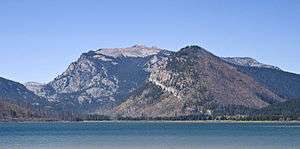 View of Webb Canyon at left from east shore of Jackson Lake. Owl Peak is the highest summit on the right. | |
| Country | United States |
|---|---|
| State | Wyoming |
| County | Teton |
| Source | |
| - coordinates | 43°54′30″N 110°48′51″W / 43.90833°N 110.81417°W [1] |
| Mouth | Jackson Lake |
| - elevation | 6,824 ft (2,080 m) [1] |
| - coordinates | 43°59′10″N 110°43′28″W / 43.98611°N 110.72444°WCoordinates: 43°59′10″N 110°43′28″W / 43.98611°N 110.72444°W [1] |
Webb Canyon is located in Grand Teton National Park, in the U. S. state of Wyoming.[2] The canyon was formed by glaciers which retreated at the end of the last glacial maximum approximately 15,000 years ago, leaving behind a U-shaped valley.[3] Webb Canyon is south of Owl Peak and the entrance to the canyon is near the northern reaches of Jackson Lake. Moose Creek flows through much of the 9 miles (14 km) long canyon and the Webb Canyon Trail traverses the length of the canyon to Moose Basin Divide.
See also
References
- 1 2 3 "Webb Canyon". Geographic Names Information System. United States Geological Survey. Retrieved 2011-05-21.
- ↑ Colter Bay, WY (Map). TopoQwest (United States Geological Survey Maps). Retrieved 2011-05-21.
- ↑ "Park Geology". Geology Fieldnotes. National Park Service. Retrieved 2011-05-21.
This article is issued from Wikipedia - version of the 2/2/2015. The text is available under the Creative Commons Attribution/Share Alike but additional terms may apply for the media files.