Wesenitz
| Wesenitz | |
|---|---|
 Wesenitz near Helmsdorf (Stolpen) | |
| Country | Germany |
| Basin | |
| Main source | Lausitzer Bergland |
| River mouth |
Elbe 50°57′49″N 13°53′39″E / 50.96361°N 13.89417°ECoordinates: 50°57′49″N 13°53′39″E / 50.96361°N 13.89417°E |
| Physical characteristics | |
| Length | 83 km (52 mi) |
The Wesenitz is a river in the Free State of Saxony, Germany, right tributary of the Elbe. Its total length is 83 km. The Wesenitz runs through the tourist regions of the Lusatian Highlands and Saxon Switzerland. Its name is derived from Sorbian language wjaz (Elm).[1]
Geography
The Wesenitz originates near Neukirch/Lausitz and flows southwest through Bischofswerda, passes Großdrebnitz, flows through Stolpen and Dürrröhrsdorf-Dittersbach. The Wesenitz joins the Elbe near Pirna.
Touristic Attractions
Stolpen Castle is officially documented first time for the year 1222 when it was a property of the Bishop of Dresden-Meissen. In 1559 it had been passed over to Augustus, Elector of Saxony. The castle's fame originates from the period 1716 till 1765 when Augustus II the Strong imprissoned here his mistress Countess of Cosel.
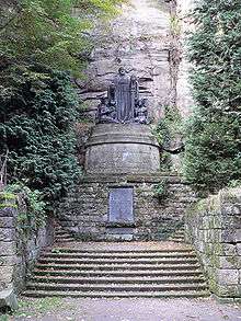
The Liebethaler Grund, the "Gateway to Saxon Switzerland", is a picturesque ravine. Near a former hydropower station the world's biggest memorial to Richard Wagner can be visited.
Historical Usage
Beginning with the inauguration of Johann V. of Weißenbach in 1476, the Bishops of Meißen until 1559 and later the prince-electors of Saxony performed fish farming of carps in two ponds between Goldbach and Kleindrebnitz respectively in Bischofswerda, which were fed with Wesenitz water. The fish farms were of approximately 20 ha each and had to be closed due to economic and technical reasons about 1815.[2]

In 1895, 63 industrial plants made use of the water power, among them 44 mills.[3] Today, five such water mills can still be visited. One of them with two Francis turbines is operated by Lohmen in the Liebethaler Grund.
Fauna
With an average width of 10 m and an average slope of 0.53%, grayling resp. brown trouts are the leading species in the lower and middle part, resp. the upper part of the river Wesenitz.
Down from Helmsdorf, the river Wesenitz is protected according Habitats Directive,[4] referring to the appearance of European bullhead and common minnow. In 1994, the salmon was renaturalized.
The Wesenitz historically inhabited a large population of otters, which were hated by the fishermen. The otters been extinct until 1920, but revived in recent years due to conservation measures. Since 1969, a migration from the river system of Schwarze Elster is reported at Großharthau respectively Bischofswerda and is noticed in traffic victims at crossing points over the B6.[5]
References
- ↑ Jan Meschgang: Die Ortsnamen der Oberlausitz; Domowina Verlag, Bautzen 1973; S. 97
- ↑ Frank Fiedler. Historische Teichwirtschaft im Raum Bischofswerda. Zwischen Wesenitz und Löbauer Wasser 3. Heimatblätter des Landkreises Bautzen. S. 41-49, 1998
- ↑ Bruno Steglich. Die Fischwässer im Königreiche Sachsen: Darstellung der gesammten sächsischen Fischereiverhältnisse, hrsg. vom Sächsischen Fischerei-Verein, bearbeitet von B. Steglich. Dresden Schönfeld in Komm., 1895
- ↑ Nr. 162 in der Liste der FFH-Gebiete wegen gemeinschaftlicher Bedeutung für die EU gemäß Anhang II der EU Richtlinie 92/43/EWG
- ↑ Frank Fiedler. Zum Vorkommen des Fischotters im Landkreis Bischofswerda. Ber. Naturforsch. Gesellschaft Oberlausitz, Görlitz. H. 2, S. 35-39, 1993
| Wikimedia Commons has media related to Wesenitz. |