Western Interior Seaway

The Western Interior Seaway (also called the Cretaceous Seaway, the Niobraran Sea, and the North American Inland Sea) was a large inland sea that existed during the mid- to late Cretaceous period as well as the very early Paleogene, splitting the continent of North America into two landmasses, Laramidia to the west and Appalachia to the east. The ancient sea stretched from the Gulf of Mexico and through the middle of the modern-day countries of the United States and Canada, meeting with the Arctic Ocean to the north. At its largest, it was 2,500 feet (760 m) deep, 600 miles (970 km) wide and over 2,000 miles (3,200 km) long.
Origin and geology
The Seaway was created as the Farallon tectonic plate subducted under the North American Plate during the Cretaceous. As plate convergence proceeded, the younger and more buoyant lithosphere of the Farallon Plate subducted at a shallow angle, in what is known as a "flat slab". This shallowly subducting slab exerted traction on the base of the lithosphere, pulling it down and producing dynamic topography at the surface that caused the opening of the Western Interior Seaway.[1] This depression and the high eustatic sea levels existing during the Cretaceous allowed waters from the Arctic Ocean in the north and the Gulf of Mexico in the south to meet and flood the central lowlands, forming a sea that transgressed (grew) and regressed (receded) over the course of the Cretaceous.
The earliest phase of the Seaway began in the mid-Cretaceous when an arm of the Arctic Ocean transgressed south over western North America; this formed the Mowry Sea, so named for the Mowry Shale, an organic-rich rock formation.[2] In the south, the Gulf of Mexico was an extension of the Tethys Sea, which met with the Mowry Sea in the late Cretaceous, forming the "complete" Seaway.[2]
At its largest, the Western Interior Seaway stretched from the Rockies east to the Appalachians, some 1,000 km (620 mi) wide. At its deepest, it may have been only 800 or 900 metres (2,600 or 3,000 ft) deep, shallow in terms of seas. Two great continental watersheds drained into it from east and west, diluting its waters and bringing resources in eroded silt that formed shifting delta systems along its low-lying coasts. There was little sedimentation on the eastern shores of the Seaway; the western boundary, however, consisted of a thick clastic wedge eroded eastward from the Sevier orogenic belt.[2][3] The western shore was thus highly variable, depending on variations in sea level and sediment supply.[2]

Widespread carbonate deposition suggests that the Seaway was warm and tropical, with abundant calcareous algae.[4] Remnants of these deposits are found throughout the state of Kansas. One prominent example is Monument Rocks (Kansas), an exposed chalk formation towering 70 feet (21 m) over the surrounding range land. It is designated a National Natural Landmark and one of the Eight Wonders of Kansas. It is located 25 miles (40 km) south of Oakley, Kansas. [5]
At a few times during the late Cretaceous the Western Interior Seaway went through periods of anoxia, where the bottom water was devoid of oxygen and the water column was stratified.
At the end of the Cretaceous, a continuing uplift in a mountain-building episode called the Laramide orogeny hoisted the sandbanks (sandstone) and muddy brackish lagoons (shale) – the thick sequences of silt and sandstone still seen today as the Laramie Formation – while low-lying basins between them gradually subsided. The Western Interior Seaway divided across the Dakotas and retreated south towards the Gulf of Mexico. This shrunken, regressive phase of the Western Interior Seaway is sometimes called the Pierre Seaway.[2]
During the early Paleocene, parts of the Western Interior Seaway (marine waters) still occupied areas of the Mississippi Embayment, submerging the site of present-day Memphis. Later transgression, however, was associated with the Cenozoic Tejas sequence, rather than with the previous event responsible for the Seaway.
Fauna
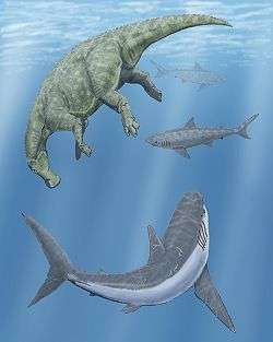
The Western Interior Seaway was a shallow sea, filled with abundant marine life. Interior Seaway denizens included predatory marine reptiles such as plesiosaurs, and mosasaurs that grew up to 18 metres (59 ft) long. Other marine life included sharks such as Squalicorax and the giant shellfish-eating Ptychodus mortoni (believed to be 10 metres (33 ft) long);[6] and advanced bony fish including Pachyrhizodus, Enchodus, and also the massive 5-metre (16 ft) long Xiphactinus – a fish larger than any modern bony fish. Other sea life included invertebrates such as mollusks, ammonites, squid-like belemnites, and plankton including coccolithophores that secreted the chalky platelets that give the Cretaceous its name, foraminiferans and radiolarians.
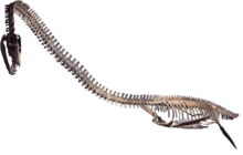
The Western Interior Seaway was home to early birds also, including the flightless Hesperornis which had stout legs for swimming through water and small wing-like appendages used for marine steering rather than flight; and the tern-like Ichthyornis, an early avian with a toothy beak. Icthyornis shared the sky with large pterosaurs such as Nyctosaurus and Pteranodon. Pteranodon fossils are very common and it was probably a major component of the surface ecosystem, though it was found in only the southern reaches of the Seaway.[7]
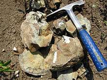
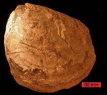
On the bottom, the giant clam Inoceramus left common fossilized shells in the Pierre Shale. This clam had a thick shell paved with "prisms" of calcite deposited perpendicular to the surface, giving it a pearly luster in life. Paleontologists suggest that its giant size was an adaptation for life in the murky bottom waters, where a correspondingly large gill area would have allowed the animal to cope with oxygen-depleted waters.
See also
- Geology of the Bryce Canyon area
- Zuñi sequence
- Sundance Sea, a separate seaway of the Jurassic
- Pierre Shale
- Hudson Seaway
- Lake Agassiz, a later glacial lake covering some of the same area
References
- ↑ Mitrovica, J. X.; Beaumont, C.; Jarvis, G. T. (1989). "Tilting of continental interiors by the dynamical effects of subduction". Tectonics. 8: 1079. Bibcode:1989Tecto...8.1079M. doi:10.1029/TC008i005p01079.
- 1 2 3 4 5 Stanley, Steven M. (1999). Earth System History. New York: W.H. Freeman and Company. pp. 487–489. ISBN 0-7167-2882-6.
- ↑ Monroe, James S.; Wicander, Reed (2009). The Changing Earth: Exploring Geology and Evolution (5th ed.). Belmont, CA: Brooks/Cole, Cengage Learning. p. 605. ISBN 0495554804.
- ↑ "Oceans of Kansas Paleontology". Mike Everhart. Retrieved 2007-02-06.
- ↑ http://www.kansastravel.org/monumentrocks.htm
- ↑ Walker, Matt (24 February 2010). "Giant predatory shark fossil unearthed in Kansas". BBC Earth News. Retrieved 16 April 2013.
- ↑ Benton, S.C. (1994). "The Pterosaurs of the Niobrara Chalk." The Earth Scientist, 11(1): 22-25.