Westwood Plateau
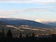
Westwood Plateau is a neighbourhood in the northern region of Coquitlam, British Columbia, bounded by the city boundary with Port Moody to the west, David Avenue to the south, and Pipeline Road to the east. It lies on 1,400 acres (6 km2) on the southern portion of Eagle Mountain, known locally as Eagle Ridge.
It is named for Westwood Motorsport Park which existed on the plateau before the community was built, and was closed in 1990 to make way for real estate development.[1] Hampton Park Elementary School was built on top of the actual raceway.
History
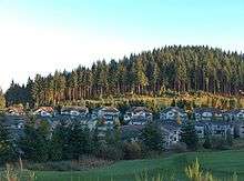
The area currently known as Westwood Plateau was crown land purchased by Wesbild Corp. in 1989, and between then and 2005 transformed the area into a residential community of 4525 homes and in 2010 is home to about 15,000 residents.[2]
Features
The area features extensive greenbelts that protect existing creeks. Almost half the area, or 700 acres (2.8 km2) was retained as green space in this way, including a 400 meter high promontory at the center of Ridge Park. 2349 Detached single family style homes make up the majority of the buildings in the area. Lot sizes per home vary between 0.10 and 0.30 acres (1,200 m2), with most being in the 0.10 to 0.15-acre (610 m2) range. Townhomes, duplexes, and condominium style homes contribute another 2174 units. Due to the extensive preservation of natural areas the effective population density is less than 12 people per acre making it a low density suburb. However, the built-up area itself, at 22 people per acre, would classify it as a compact neighborhood. Although touted as a plateau the area is actually sloped rising from between 60 and 100 metres above sea level to almost 400 metres. Some roadways are quite steep but mostly gently curving roads climb to the top where a golf course is located.
Transportation
Private automobile provides the fastest means of transport as Coquitlam and surrounding areas are amply provided with roads and free parking. The area is served by public transit buses at a minimum frequency of every thirty minutes most of the day. Service increases to every fifteen minutes during peak hours and reduces to once per hour late at night. Travel times on bus to Downtown Port Moody or Downtown Coquitlam are 15–20 minutes. The West Coast Express commuter rail service to Downtown Vancouver leaves from Coquitlam and Port Moody during weekday peak.
Schools
- Elementary
- Bramblewood Elementary
- Panorama Heights Elementary
- Pinetree Elementary
- Hampton Park Elementary
- Middle School
Leisure
Retail
- Westwood Plateau Village
References
- ↑ "Westwood". Modern Motorcycling, 1999. Retrieved 31 January 2009.
- ↑ "Westwood Plateau". Inwest Investments. Archived from the original on 2010-09-26.
Coordinates: 49°18′N 122°47′W / 49.300°N 122.783°W