Wetterhorn
| Wetterhorn | |
|---|---|
|
The Wetterhorn above Grindelwald | |
| Highest point | |
| Elevation | 3,692 m (12,113 ft) |
| Prominence | 202 m (663 ft) [1] |
| Parent peak | Mittelhorn |
| Coordinates | 46°38′19.5″N 8°6′55.9″E / 46.638750°N 8.115528°ECoordinates: 46°38′19.5″N 8°6′55.9″E / 46.638750°N 8.115528°E |
| Geography | |
 Wetterhorn Location in Switzerland | |
| Location | Bern, Switzerland |
| Parent range | Bernese Alps |
| Climbing | |
| First ascent | 31 August 1844 by Melchior Bannholzer and Hans Jaun |
| Easiest route | rock/snow/ice climb |
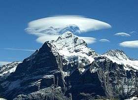
The Wetterhorn (3,692 m) is a mountain in the Swiss Alps towering above the village of Grindelwald. Formerly known as Hasle Jungfrau, it is one of three summits of a mountain named Wetterhorn sensu lato, or the "Wetterhörner", the highest summit of which is the Mittelhorn (3,704 m) and the most distant the Rosenhorn (3,689 m). The Mittelhorn and Rosenhorn are mostly hidden from view from Grindelwald.
The Grosse Scheidegg Pass crosses the col to the north, between the Wetterhorn and the Schwarzhorn.[2]
Ascents
The Wetterhorn summit was first reached on August 31, 1844, by the Grindelwald guides Hans Jaun and Melchior Bannholzer, three days after they had co-guided a large party organized by the geologist Édouard Desor to the first ascent of the Rosenhorn. The Mittelhorn was first summitted on 9 July 1845 by the same guides, this time accompanied by a third guide, Kaspar Abplanalp, and by Stanhope Templeman Speer. The son of a Scottish physician, Speer lived in Interlaken, Switzerland.[3][4]

A September 1854 ascent by a party including Alfred Wills is much celebrated in Great Britain. Apparently believing to be the first ascendant, Wills' description of this trip in his book "Wanderings Among the High Alps" (published in 1856) helped make mountaineering fashionable in Britain and ushered in the systematic exploration of the Alps by British mountaineers, the so-called golden age of alpinism. Despite several well-documented earlier ascents and the fact that he was guided to the top, even in his obituary in 1912 he was considered to be "certainly the first who can be said with any confidence to have stood upon the real highest peak of the Wetterhorn proper" (i.e. the 3,692 m summit)[5] In a subsequent corrigendum, the editors admitted two earlier ascents, but considered his still "the first completely successful" one.[6]
In 1866, Lucy Walker was the first documented female ascendant of the peak.
The 24-year-old English mountaineer William Penhall and his Meiringen guide Andreas Maurer were killed by an avalanche high up on the Wetterhorn on 3 August 1882.
The famed guide and Grindelwald native Christian Almer climbed the mountain many times in his life, including on his first of many trips with Meta Brevoort and her nephew W. A. B. Coolidge in 1868. His last ascent was in 1898 at the age of 70 together with his wife to celebrate their golden anniversary on top.
Winston Churchill climbed the Wetterhorn in 1894.
Aerial tramway
The Wetterhorn summit was the intended terminal for the world's first passenger carrying aerial tramway, but only the first quarter was built. It was in operation until the beginning of World War I.
References
- ↑ Retrieved from the Swisstopo topographic maps and Google Earth. The key col is located near the Wettersattel at 3,490 metres.
- ↑ map.geo.admin.ch (Map). Swiss Confederation. Retrieved 2015-05-18.
- ↑ Williams, Charles (1854). The Alps, Switzerland, and the North of Italy. J. Cassell. pp. 319–326.
- ↑ Chambers, William; Chamber, Robert (1846). Chambers's Journal. Volume 5. pp. 59–61.
- ↑ In memoriam. Rt. Hon. Sir alfred Wills, The Alpine Journal 27, 1912, pp. 47-
- ↑ Addenda and Corrigenda: The Wetterhorn, The Alpine Journal 27, 1912, p. 235
External links
| Wikimedia Commons has media related to Wetterhorn. |
- The Wetterhorn on Summitpost
- The Wetterhorn from Grindelwald First
- The Wetterhorn from the Eiger Trail