Wharram-le-Street
| Wharram-le-Street | |
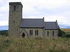 St Mary's parish church |
|
 Wharram-le-Street |
|
| OS grid reference | SE8665 |
|---|---|
| Civil parish | Wharram-le-Street |
| District | Ryedale |
| Shire county | North Yorkshire |
| Region | Yorkshire and the Humber |
| Country | England |
| Sovereign state | United Kingdom |
| Post town | Malton |
| Postcode district | YO17 |
| Dialling code | 01944 |
| Police | North Yorkshire |
| Fire | North Yorkshire |
| Ambulance | Yorkshire |
| EU Parliament | Yorkshire and the Humber |
Coordinates: 54°04′54″N 0°40′57″W / 54.0818°N 0.6824°W
Wharram-le-Street is a village and civil parish in the Ryedale district of North Yorkshire, England. The population at the 2011 census was less than 100. Details are included in the civil parish of Thixendale. Until the 1974 local government reorganisation Wharram-le-Street was part of the East Riding of Yorkshire. The village is on the B1248 road between North Grimston and the boundary with the present East Riding unitary authority.
The affix "le-Street" in the toponym refers to the fact that the village is beside the course of a former Roman road. The Domesday Book of 1086 records the manor as Warham. About 1 mile (1.6 km) south of the village is the deserted medieval village of Wharram Percy.
The Church of England parish church of St Mary is late Anglo-Saxon.[1] The nave and lower part of the west tower were built in the early or mid-11th century, in the last decades before the Norman conquest of England.[1] The top of the tower is slightly later, representing the Saxo-Norman overlap architecture of the late 11th or early 12th century.[1] The chancel arch is pure Norman, the north aisle was added in the 14th century and the chancel was rebuilt in 1862–64.[2]
St Mary's is now a Grade I listed building.[3] The parish is now part of a joint benefice with the parishes of East Lutton, Helperthorpe, Kirby Grindalythe, Weaverthorpe and West Lutton.[4]
Wharram railway station on the Malton and Driffield Railway served the village from 1853 to 1950.[5]
References
- 1 2 3 Pevsner 1972, p. 367.
- ↑ Pevsner 1972, p. 368.
- ↑ Historic England. "Church of Saint Mary (1149064)". National Heritage List for England. Retrieved 25 October 2013.
- ↑ Archbishops' Council (2010). "St Mary, Wharram le Street". A Church Near You. Church of England. Retrieved 25 October 2013.
- ↑ Butt, R. V. J. (1995). The Directory of Railway Stations: details every public and private passenger station, halt, platform and stopping place, past and present (1st ed.). Sparkford: Patrick Stephens Ltd. ISBN 1-8526-0508-1. OCLC 60251199.
Sources
- Pevsner, Nikolaus (1972). Yorkshire: York & the East Riding. The Buildings of England. Harmondsworth: Penguin Books. pp. 367–8. ISBN 0-14-0710-43-4.
External links
| Wikimedia Commons has media related to Wharram-le-Street. |
- Wharram-le-Street in the Domesday Book