White Lake (Ontario)
| White Lake | |
|---|---|
 | |
| Location | Ontario |
| Coordinates | 45°18′36″N 76°31′12″W / 45.31000°N 76.52000°W |
| Primary outflows | Indian Creek, Waba Creek |
| Basin countries | Canada |
| Max. length | 16 km (9.9 mi) |
| Surface area | 22.7 km2 (8.8 sq mi) |
| Shore length1 | 98 km (61 mi) |
| Settlements | White Lake, Ontario |
| 1 Shore length is not a well-defined measure. | |
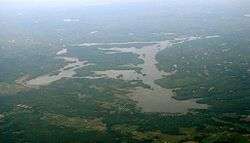
White Lake is a medium-sized lake of Ontario, Canada. It is located 60 km west of Ottawa, Ontario near Calabogie to the west and Arnprior to the north. It may be accessed via Highway 417 from Ottawa or Renfrew Country Road 511 from Perth. The town of White Lake lies on the northern shore of the lake.
The northern and western shores of White Lake mark the upper limit of the Champlain Sea which flooded the Ottawa Valley at the end of the last ice age.[1]
The lake dimensions are:
- length: 10 miles / 16 km
- area: 5608 acres / 2270 hectares
- perimeter: 60.8 miles / 98 km
The lake is marked in Canada by National Resources Canada with the CGNDB Unique Identifier: FDDES.
History
Before European settlement the lake was known as Wa-ba-lac by the local natives. In the Johnston Royal atlas (dated 1860) the lake was shown as Wabak or White Lake. The lake name is believed to be derived from the white marl deposits covering large portions of the lake substrate.[2] White Lake was created in 1845 when a dam on Waba Creek was constructed resulting in the water levels increasing in three previously small, interconnected waterbodies. The dam was originally constructed to facilitate the movement of logs to Stewart's sawmill further downstream.[3] The dam was rebuilt and repaired several times during the 1900's and currently exits as a 0.2 MV Hydroelectic Dam operated by Misty Rapids Power.[4]
In the 1970's Summer water levels were stabilized for the benefit of boaters and shoreline property owners. Recently, there has been concern over the presence of Algal Bloom which has become more prevalent as shorelines are developed and local human presence increases.[5]
Ecology
Prior to 1930 White Lake supported a northern pike fishery. With intensive stocking a walleye fishery developed during the period between 1930 and the mid 1960's. Since that time, largemouth Bass and northern pike have been the most sought after game fish with walleye being seen only periodically in the anglers catch.[6] Sunfish are also commonplace in White Lake.[7]
The lake is regionally significant for the presence of the White Lake Fen, which is a rare wetland type in Lanark County and considered to be a Provincially Significant Wetland and a Special Place.[8]
References
- ↑ Barnett, P.J. 1988. History of the northwestern arm of the Champlain Sea. Pp 25-36 in Gadd, N.R. (ed.) The Late Quaternary Development of the Champlain Sea Basin. Geological Association of Canada, Special Paper 36. Map 5.
- ↑ Kennedy, C. C. 1970. The upper Ottawa Valley, Renfrew County Council. Pembroke, Ontario
- ↑ The Fishery of White Lake ; A. Anthers nd S.J. Kerr, Technical Report TR-107, Southcentral Sciences Section, Ontario Ministry of Natural Resources, Kemptville, ON 31p. 1998
- ↑ http://www.powerauthority.on.ca/hydroelectric/stewart-generating-station-02-mw-arnprior-waba
- ↑ http://millstonenews.com/2016/02/concern-about-white-lake-trailer-park-plans.html
- ↑ The Fishery of White Lake ; A. Anthers nd S.J. Kerr, Technical Report TR-107, Southcentral Sciences Section, Ontario Ministry of Natural Resources, Kemptville, ON 1998
- ↑ http://www.whitelakeon.com/ithingstodo.html
- ↑ Keddy, P.A. 2008. Earth, Water, Fire: An Ecological Profile of Lanark County. General Store Publishing House, Renfrew, Ontario. 73 p.
See also
- List of lakes in Ontario
- The Fishery of White Lake
- Anecdotal History of White Lake
- White Lake Community Website
- National Resources Canada
- AMIK Cottage on White Lake, Ontario
- Area map
- White Lake Preservation Project
- White Lake Property Owners Association
- Statement of Conservation Interest