White Mountain Wilderness
| White Mountain Wilderness | |
|---|---|
|
IUCN category Ib (wilderness area) | |
|
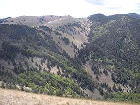
White Mountain Wilderness along the Crest Trail | |
 | |
| Location | Lincoln County, New Mexico, United States |
| Nearest city | Ruidoso, New Mexico |
| Coordinates | 33°26′15″N 105°45′01″W / 33.4375°N 105.750278°WCoordinates: 33°26′15″N 105°45′01″W / 33.4375°N 105.750278°W |
| Area | 48,266 acres (19,533 ha) |
| Established | 1964 |
| Administrator | U.S. Forest Service |
The White Mountain Wilderness is a protected wilderness area within the Lincoln National Forest, Smokey Bear Ranger District. The White Mountain Wilderness is located in the Sierra Blanca Mountains of south central New Mexico, approximately 15 miles (24 km) north northwest of the town of Ruidoso.
History
The White Mountain Wilderness was established as a primitive area by the United States Congress in 1933 and was included in the National Wilderness Preservation System in 1964. The area originally consisted of approximately 25,000 acres (10,000 ha). In 1980, additional land was added to bring the overall total to over 48,000 acres (19,000 ha).[1]
Geography and climate
This wilderness area contains approximately 48,873 acres (19,778 ha) of land and is 12.5 miles (20.1 km) long and 12 miles (19 km) wide. It consists of mainly a long, northerly running ridge and its branches. The west side of this ridge is extremely steep and rugged, while the eastern side is more gentle with broader, forested canyons and some small streams. Elevations range from 6,400 feet (2,000 m) at Three Rivers Campground on the western side to 11,580 feet (3,530 m) near Lookout Mountain in the south.[1] The summit of Sierra Blanca (White Mountain) is located on the Mescalero Indian Reservation and is reached by a 1.25 mile (2 km) trail from Lookout Mountain. Reaching 11,973 feet (3,649 m), Sierra Blanca is the southernmost mountain in the continental United States to rise above timberline.[2]
There are four different life zones within this wilderness area: pinyon-juniper, ponderosa pine, mixed conifer, and sub-alpine forest, plus alpine tundra found at the summit of Sierra Blanca just outside the wilderness boundary. Abrupt changes in elevation, escarpments, rock outcroppings, and avalanche chutes make for striking contrast and scenery. The area is also interspersed with meadows and grass-oak savannahs, which are the result of forest fires. The weather is dry and windy in springtime, with temperatures ranging from 32 °F/0 °C to 80 °F/26 °C. July and August are the rainy months with frequent afternoon showers and high temperatures averaging 85 °F/29 °C. Snows in winter do not typically begin until mid-November, and snowfall averages 6 feet (1.8 m) or more. Low temperatures during winter average around 22 °F (−6 °C), but have reached as low as −15 °F (−26 °C).[1]
Water sources are not abundant, but do exist in the form of small streams or springs scattered throughout the area. Trails with good water access include Big Bonito Trail and South Fork Trail. Although fishing is permitted within the wilderness area, few fish are found due to the small size of most streams. Although the streams run well most of the year, in times of severe drought, they may be non-existent.
Wildlife and trails
Wildlife includes mule deer, elk, black bear, turkey, porcupine, badger, bobcat, gray fox, coyote, skunk, spruce and rock squirrels, and numerous species of mice, moles, and birds. Feral hogs are also becoming abundant in this region. Hunting is permitted according to state game regulations. Additionally, as in all national forests, concealed carry of firearms for personal protection is permitted, provided the person has a concealed handgun license recognized by the state of New Mexico.
The area contains a well maintained and developed trail system with more than fifty miles of trails and nine miles (14 km) of access trails. Most trails are well marked and follow ridgelines or canyon bottoms. These trails are easily negotiated by novice to advanced hikers and backpackers as well as horse riders. Park regulations prohibit the use of motorized vehicles and mountain bikes on trails.[1]
Major access points to the wilderness include:[1]
- Three Rivers Campground on the west side via Three Rivers Trail #44
- Ski Apache ski area on the southeast side via Lookout Trail #78 and Scenic Trail #15
- South Fork Campground via South Fork Trail #19
- Argentina Canyon via Big Bonito Trail #36
- Nogal Canyon via Forest Service Road 108
- Crest Trailhead below Monjeau Lookout off Forest Road 117
 Wilderness sign
 Campers in White Mountain Wilderness
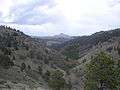 View of Nogal Peak in the White Mountain Wilderness