White Tank Mountains
| White Tank Mountains | |
|---|---|
 Petroglyphs in the White Tank Mountains | |
| Highest point | |
| Elevation | 4,083 ft (1,244 m) |
| Coordinates | 33°34′31″N 112°34′44″W / 33.57528°N 112.57889°W |
| Geography | |
| Location | Arizona, United States |
| Topo map | USGS White Tank Mountains (AZ) |
| Geology | |
| Age of rock | 35 Ma |
| Mountain type | Metamorphic |
The White Tank Mountains is a mountain range located in central Arizona. The mountains are on the western periphery of the Phoenix metropolitan area, primarily flanked by the suburban cities of Buckeye to the south and west, and Surprise to the north and east. The mountain range is home to the White Tank Mountain Regional Park and is a regional recreation hub.
The range, often referred to simply as the White Tanks, is a moderate sized mountain range whose peaks rise to an elevation of around 4,000 feet (1,219 m).[1] The range consists of a series of numerous ridges and canyons and as such lacks a single, prominent peak. The highest point in the range, at an altitude of 4,083 feet (1,244 m), is Barry Goldwater Peak.[2]
The mountain range was formed through tectonic activities as part of a detachment fault sometime in the mid Tertiary period, about 30 million years ago.[1] As a fairly young (in geologic terms) mountain range it has not been subject to the forces of erosion for long and retains an extremely rugged topography composed of rocky fault ridges and deep canyons. During seasonal heavy rainfall, accumulated water tends to rush rapidly through the steep canyons, over time scouring out a number of depressions or "tanks" in the white granite near the base of the mountains. These white "tanks" are the source of the mountains' name.[3]
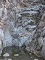 Granite "white tank" in the White Tank mountains, AZ, USA
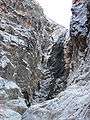 The White Tanks waterfall runs only immediately after rainfall
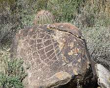 Web-like petroglyph on the White Tank Mountain Regional Park Waterfall Trail
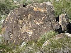 Chipping petroglyph on the White Tank Mountain Regional Park Waterfall Trail
References
- 1 2 Stephen Reynolds. "Geology of the White Tank Mountains, Central Arizona".
- ↑ "Barry Goldwater Peak". Geographic Names Information System. United States Geological Survey. 2005-05-27. Retrieved 2010-02-01.
- ↑ "White Tank Regional Park, AZ". LASR.