Wigg Island
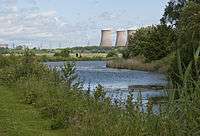
Wigg Island, also known as Wigg Island Community Park, is a Local Nature Reserve near Runcorn in Halton, Cheshire, England.[1][2] It lies between the River Mersey and the Manchester Ship Canal. It was opened on 19 April 2002 by the Mayor of Halton and Bill Oddie. The island is named after Charles Wigg, who started an alkali works there in the 1860s to extract copper from its ore. It was originally served by the Runcorn to Latchford Canal, and later by the Manchester Ship Canal. During the Second World War it was a centre for the production of mustard gas as Wiggs Works East, then Randles. After the war it was operated by ICI. Production ended in the 1960s.
The nature reserve covers 23 hectares (57 acres) and is used by birdwatchers. Bee Orchids are among the wild flowers found there. There is a visitor centre and a wind turbine.[3] It is reached via a swing bridge over the Manchester Ship Canal. The site was heavily contaminated and had to be cleaned up before use. It is managed by Halton Borough Council. It was made a Local Nature Reserve in 2004 and is a holder of Keep Britain Tidy's Green Flag Award.[4]
Wigg Island Visitor Centre
The Cheshire Wildlife Trust managed the Wigg Island Visitor Centre in Wigg Island Community Park through a partnership with Halton Borough Council. The centre is open on Fridays and Sundays from April through September. Visitor can learn about local wildlife and enjoy refreshments. As of March 2016 it was closed to the public.
References
- ↑ "Wigg Island". Local Nature Reserves. Natural England. Retrieved 26 July 2013.
- ↑ "Map of Wigg Island". Local Nature Reserves. Natural England. Retrieved 26 July 2013.
- ↑ "Halton & Tourist Attractions- Runcorn- Spike Island - Catalyst Science Discovery Centre". visithalton.com. 19 April 2002. Retrieved 21 September 2011.
- ↑ "Wigg Island Community Park". Keepbritaintidy.org. Retrieved 21 September 2011.
External links
- Wigg Island - Visit Halton
- Official info page at Halton Borough Council
- Wigg Island Visitor Centre - Cheshire Wildlife Trust
Coordinates: 53°20′53″N 2°42′14″W / 53.348°N 2.704°W