Wildenburger Kopf
| Wildenburger Kopf | |
|---|---|
|
The Wildenburger Kopf from the west-southwest. | |
| Highest point | |
| Elevation | 664 m above sea level (NHN) (2,178 ft) [1] |
| Coordinates | 49°46′34″N 7°15′24″E / 49.7761°N 7.2568°ECoordinates: 49°46′34″N 7°15′24″E / 49.7761°N 7.2568°E |
| Geography | |
 Wildenburger Kopf | |
| Parent range | Idarwald, Hunsrück |
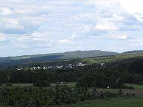
The Wildenburger Kopf is a mountain that reaches a height of 664 m above sea level (NHN)[1] in the Idar Forest in the Hunsrück mountains near the village of Kempfeld. There is a viewing tower at the summit which has been recently been built into the ruins of Wildenburg Castle. The Wildenburg Nature Reserve runs from the Wildenburger Kopf in a northeasterly direction along a rocky ridge.
References
External links
- Die Wildenburg bei Kempfeld private website: Kulturlandschaft Nahetal und Hunsrück
This article is issued from Wikipedia - version of the 12/7/2015. The text is available under the Creative Commons Attribution/Share Alike but additional terms may apply for the media files.