William C. O'Neill Bike Path
| William C. O'Neill Bike Path | |
|---|---|
|
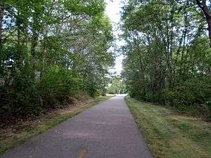
The William C. O'Neill Bike Path in Peace Dale in 2013 | |
| William C. O'Neill Bike Path | |
| Established | 2000 (first section) |
| Length | 7.8 miles (13 km) |
| Location | South Kingstown and Narragansett, Rhode Island, United States |
| Trailheads |
Kingston station, West Kingston Mumford Road, Narragansett |
| Hiking details | |
| Surface | Paved |
| Right of way | Former Narragansett Pier Railroad |
| Website | southcountybikepath.org |
The William C. O'Neill Bike Path (also called the South County Bike Trail) is a paved rail trail extending from Kingston station parking lot in West Kingston, Rhode Island, to Mumford Road in Narragansett, Rhode Island. The whole path is in Washington County, Rhode Island. The trail is 7.8 miles (13 km) long, largely on the former right of way of the Narragansett Pier Railroad. A future extension will bring it to Boston Neck Road (RI 1A).
History

The Narragansett Pier Railroad opened in 1876 to connect mills in Wakefield and Peace Dale to the New York, Providence and Boston Railroad at West Kingston.[1] Passenger service ended in 1952, though freight service continued until the 1970s and the line was not fully abandoned until 1981.[1]
In 1968, the line was proposed for use as a public school rail line, taking children to and from schools along the route, but this "visionary concept" failed to gain the requisite support.[2] In 1981, Anthony Guariello—a local mill owner and town councilman—purchased the line with the possibility of conversion into a bike path for school children.[3]
Conversion to a bicycle path was studied in 1991; in 1995, the Friends of the South County Bike Path was started to create the path.[3] The first phase of the trail, running 4.2 miles (6.8 km) from Kingston station to Rodman Street, was completed in 2000. The 2.9-mile (4.7 km) Phase II was opened to Route 108 in 2003. Phase II, started in 2009, and opened in 2011, extended the trail a further 0.8 miles (1.3 km) (including a short section on a residential street) to the intersection of Mumford Road and Riverside Drive in Narragansett.[4][5] According to the Rhode Island Department of Transportation, at 7.8 miles, the South County Bike Path is the fourth longest bike path in the state.[4]
The last section of railroad right-of-way through Narragansett is not as well-preserved as the rest of the route; several parts are used for roads or residential developments. Instead, Phase IV will be routed through the Canonchet Farm, a local park, and reach the waterfront north of where the railroad did.[6] Although more expensive than on-road alternatives, it will provide the safest route. The project was entered into funding proposals in early 2016.[7]


Street crossings
The William C. O'Neill Bike Path crosses the following streets:[8]
| Town | Road | Notes |
|---|---|---|
| West Kingston | Railroad Avenue (Kingston station) | Western terminus of path. Parking lot located off Route 138.[8] |
| Liberty Lane | ||
| Larkin Pond Road North | ||
| South Kingstown | South Road | |
| Curtis Corner Rd. | ||
| Unnamed driveway | Dirt road | |
| Asa Pond Road | ||
| Rodman Street | ||
| The trail crosses Route 108 twice in short succession | ||
| Railroad Avenue | Concurrent with street | |
| Church Street | ||
| Cemetery Lane | ||
| Woodruff Avenue | Overhead bridge – no connection to trail | |
| Prospect Street | ||
| Robinson Street | ||
| McArthur Street | Concurrent with street | |
| Narragansett | Overhead bridge – no connection to trail | |
| Mumford Road | Eastern terminus of current path[8] |
Phase IV junctions (as of 2016)
The proposed fourth phase of the bike path is planned to cross the following streets:[6][9]
| Town | Road | Notes |
|---|---|---|
| Narragansett | Riverside Drive | Overlap |
| Future eastern terminus of path. Short walk to town beach. |
References
- 1 2 Lewis, Edward A. (1975). American Short Line Railway Guide. The Baggage Car. p. 87.
- ↑ "A Brief History of the William C. O'Neill Bike Path". southcountybikepath.org. Friends of the William C. O'Neill Bike Path. 2009. Retrieved 2016-09-01.
- 1 2 "South County Bike Path". southcountybikepath.org. Retrieved 2016-06-21.
- 1 2 "South County Bike Path – Rhode Island". Rhode Island Department of Transportation. Retrieved 2016-06-21.
- ↑ "William C. O'Neill Bike Path | Rhode Island Trails | TrailLink.com". www.traillink.com. Retrieved 2016-08-17.
- 1 2 Rhode Island Department of Transportation (6 January 2016). "Completion of the South County Bike Path via Canonchet Farm, Narragansett, R.I." (PDF). Friends of the William C. O'Neill South County Bike Path.
- ↑ "Bike Path". www.narrowriver.org. Retrieved 2016-08-17.
- 1 2 3 Spliner, Steve. "Map of the Willam C. O'Neill Bike Path" (PDF). Willam C. O'Neill Bike Path. Retrieved July 27, 2016.
- ↑ "William C. O'Neill Bike Path | West Kingston Rhode Island Rails-To-Trails | Trails.com". www.trails.com. Retrieved 2016-08-17.
External links
| Wikimedia Commons has media related to South County Bike Path. |