Williams River (Vermont)


The Williams River is a 27.0-mile (43.5 km)[1] river in the U.S. state of Vermont. It is a tributary of the Connecticut River. Its watershed covers 117 square miles; land use is about 80% forested and 4% agricultural, and the upper river supports wild brook trout and brown trout.[2]
The river was named for Rev. John Williams of Deerfield, MA. He preached the first Christian sermon in what would become Vermont near the mouth of the river on March 5, 1704.[3] At the time, he and part of his congregation were captives of the French, the Mohawk and the Abenaki after the Deerfield Massacre, being marched from Deerfield, MA to Quebec, Canada.[4]
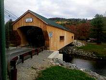
The Williams River rises in the northern part of the town of Andover and flows east through a corner of Ludlow and into Chester, where it turns southeast. Then river flows in a narrow valley near Vermont Route 103 between rolling hills into the town of Rockingham, where it joins the Connecticut River at Herricks Cove. Its watershed lies south of the Black River watershed, which includes most of Springfield, and north of the Saxtons River watershed. In Rockingham it flows over Brockways Mills Falls [5] and through the gorge below them, and is crossed by the Bartonsville Covered Bridge that was washed away in Hurricane Irene in August 2011, rebuilt in 2012, and reopened in January 2013.
The river is a target for prospectors who can be seen panning for placer gold, south of the Town of Ludlow, near the site of the Rio Tinto open-pit talc mine.
See also
References
- ↑ U.S. Geological Survey. National Hydrography Dataset high-resolution flowline data. The National Map, accessed April 1, 2011
- ↑ Williams River basin summary http://www.vermontconservation.org/Basin-11/Williams-River-Summary.html
- ↑ Hayes, Lyman S. 1907. History of the Town of Rockingham, Vermont: Including the Villages of Bellows Falls, Saxtons River, Rockingham, Cambridgeport and Bartonsville, 1753-1907, with Family Genealogies. Published by Bellows Falls, VT. Retrieved 6-12-14 at https://play.google.com/books/reader?id=ULmlDG8KLjYC&printsec=frontcover&output=reader&authuser=0&hl=en&pg=GBS.PA2
- ↑ Williams, Stephen. 1837. A Biographical Memoir of the Rev. John Williams, First Minister of Deerfield, MA. C.J.J. Ingersoll, Greenfield, MA. Retrieved 6-12-14 from https://archive.org/stream/abiographicalme00willgoog#page/n46/mode/2up
- ↑ Waterfalls of the Northeastern United States http://www.northeastwaterfalls.com/database.php?browse=st&sort=VT
- U.S. Geological Survey topographic maps, 1:100,000-scale series, Claremont (NH) quadrangle
- U.S. Geological Survey Geographic Names Information System: Williams River
Coordinates: 43°20′11″N 72°40′28″W / 43.3363953°N 72.6745717°W