Woodham Mortimer
| Woodham Mortimer | |
 Woodham Mortimer |
|
| Population | 641 (2011)[1] |
|---|---|
| OS grid reference | TL815044 |
| District | Maldon |
| Shire county | Essex |
| Region | East |
| Country | England |
| Sovereign state | United Kingdom |
| Post town | Maldon |
| Postcode district | CM9 |
| Dialling code | 01245 & 01621 |
| Police | Essex |
| Fire | Essex |
| Ambulance | East of England |
| EU Parliament | East of England |
| UK Parliament | Witham |
Coordinates: 51°42′32″N 0°37′41″E / 51.709°N 0.628°E
Woodham Mortimer is a village on the Dengie peninsula about three miles west-south-west of Maldon in the English county of Essex. The village is part of the Wickham Bishops and Woodham ward of the Maldon district.[2]
History
The discovery of a hoard of denarii dated to 41 CE[3] is some evidence of occupation in Roman times. However, the village first appears in written records as "Wudeham" in c. 975. The name, which means "village in the wood",[4] is derived from the old English words "wudu" (wood in modern English)[5] and "ham" (home, or homestead).[6] At the time of the Norman Conquest the parish belonged to Ralph Peverell and was known as Little Woodham. Henry II gave the parish to Robert de Mortimer, leading to the change in name.[7]
In the Domesday Book the population was recorded as 14 households with the local lord in 1066 being Siward Barn.[8]
During the First World War a new aerodrome was opened in nearby Stow Maries to provide air cover for the London area. 37 Squadron, Royal Flying Corps occupied the base from September 1916 taking over The Grange in Woodham Mortimer as its headquarters.[9][10] The Grange was once the property of Beeleigh Abbey and is a Grade II listed building.[11]
Demographics
Approximately 45% of residents are classified using Experian's Mosaic system as type A4 (defined as 'financially secure couples, many close to retirement, living in sought after suburbs')[12] and are predominantly white, Christian, English speaking and British born.[13] As of 2009 the population was estimated at 641.[1]
Governance
Woodham Mortimer has a parish council[14] and is part of the Wickham Bishops and Woodham ward of the Maldon district.[2] The district forms part of the Witham constituency for parliamentary elections. The local MP is Priti Patel.[15]
Geography
Woodham Mortimer has an average elevation of 51 metres (167 ft) above sea level and lies just south of the Danbury-Tiptree ridge that marks the furthest extent of the Anglian ice sheet during the last ice age approximately 450,000 years ago.[16] The geology of the area is rock, sand and gravels that were deposited by the retreating ice.[17] Gravel is commercially extracted from the Royal Oak Quarry with a proposed additional site at Tynedales Farm of 47.5 hectares (117 acres).[18] The National Soil Resources Institute at Cranfield University describes the main soil type as "slowly permeable seasonally wet slightly acid but base-rich loamy and clayey soils."[19]
Climate
Woodham Mortimer is considered by the Met Office to be part of the Eastern England region, however, for the purposes of historical climate data it is consolidated into the East Anglia region. Climate information for the period 1981 – 2010 is detailed below.
| Climate data for East Anglia (1981–2010 averages) | |||||||||||||
|---|---|---|---|---|---|---|---|---|---|---|---|---|---|
| Month | Jan | Feb | Mar | Apr | May | Jun | Jul | Aug | Sep | Oct | Nov | Dec | Year |
| Average high °F (°C) | 44.8 (7.1) |
45.3 (7.4) |
50.5 (10.3) |
55.6 (13.1) |
61.9 (16.6) |
67.3 (19.6) |
72 (22.2) |
71.8 (22.1) |
66.2 (19.0) |
58.5 (14.7) |
50.4 (10.2) |
45.1 (7.3) |
57.6 (14.2) |
| Average low °F (°C) | 34.5 (1.4) |
34 (1.1) |
37 (2.8) |
39.6 (4.2) |
44.8 (7.1) |
50 (10.0) |
54 (12.2) |
53.8 (12.1) |
50.2 (10.1) |
45.1 (7.3) |
39.2 (4.0) |
35.1 (1.7) |
43.2 (6.2) |
| Average rainfall inches (mm) | 2.094 (53.2) |
1.563 (39.7) |
1.713 (43.5) |
1.756 (44.6) |
1.921 (48.8) |
2.083 (52.9) |
2.031 (51.6) |
2.197 (55.8) |
2.091 (53.1) |
2.555 (64.9) |
2.417 (61.4) |
2.142 (54.4) |
24.57 (624) |
| Source: Met Office | |||||||||||||
Economy
There are two public houses, the Royal Oak on the A414 and the Hurdlemakers Arms on Post Office Road. Its name refers to the hurdles which used to be made from materials cut in the nearby woods.[21] There is a golf driving range with 9-hole pitch and putt that was opened in 1967[22] on Burnham Road.
Crime
Woodham Mortimer is policed by Essex Police and is part of the Purleigh Neighbourhood Policing Team which covers a number of areas with a total population of 10,936.[23] In 2011, there were 516 reported crimes in the NPT. There is no local police station.[23]
Culture and facilities
Village hall
Next to the village hall is a 0.4 hectares (4,000 m2) playing field with swings and a small football pitch.[24]
Religious sites

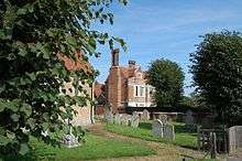
The parish church is St Margaret's. The original church on the site may date from the 16th century, however, it was rebuilt in the 19th century leaving little evidence of the older church with only the south wall and east end remaining.
Evidence for the age of the church includes the 13th century font (although the base is newer) and the 17th century carvings on the pulpit. The church has a small window commemorating Queen Victoria's diamond jubilee. The graveyard includes the grave of Peter Chamberlen.[25]
Landmarks
Woodham Mortimer Hall is a 17th-century gabled house that Hugh and Peter Chamberlen lived in. There is a blue plaque fixed to the hall[25] noting them as pioneering obstetricians who invented the forceps. The hall passed out of the Chamberlen family in 1715 when the family home was sold.[26] The forceps were found in 1813 under a trap door in the loft of the hall and given to the Medical and Chirurgical Society which passed them to the Royal Society of Medicine in 1818.[26][27] The find was described by R. Lee in Observations on the Discovery of the Original Obstetric Instruments of the Chamberlens (1862) as:
The [space] contained some boxes in which were two or three pairs of midwifery forceps, several coins, a medallion of Charles I, or II, a miniature of the Doctor damaged by time, a tooth wrapped in paper, written on, "My husband's last tooth"; some little antique plate; a pair of ladys long yellow kid gloves, in excellent preservation; a small testament date 1645.[26]

There is a war memorial commemorating the nine people from the village who died during the World Wars. There is also a Grade II listed memorial erected in 1825 to William Alexander, who left his lands to the Worshipful Company of Coopers for the benefit of the poor.[28]
Woodham Mortimer Lodge is a Grade II listed building.[29]
References
- 1 2 "Parish population 2011". Retrieved 23 September 2015.
- 1 2 "Maldon District Council". Retrieved 3 November 2008.
- ↑ B. C. Burnham, L. J. F. Keppie, A. S. Esmonde Cleary, M. W. C. Hassall and R. S. O. Tomlin. "Roman Britain in 1992". Britannia. Society for the Promotion of Roman Studies: 302. doi:10.2307/526740. ISSN 0068-113X.
- ↑ Reaney, P.H. & Wilson, R.M. (1958). A Dictionary of English Surnames. Routledge. p. 3480. ISBN 0-415-05737-X. Retrieved 22 October 2012.
- ↑ Jones, Graham & Langton, John. "Woodland Terms in Place Names". St Johns College Research Centre, University of Oxford. Retrieved 22 October 2012.
- ↑ Mills, A.D. (1991). Oxford Dictionary of British Place Names. Oxford University Press. ISBN 0198527586.
- ↑ Directory of the County of Essex. White's. 1848.
- ↑ "Woodham Mortimer". Open Domesday. Retrieved 6 February 2014.
- ↑ Ivor Dallinger. "Stow Maries Aerodrome". Retrieved 23 October 2012.
- ↑ "37 Squadron RFC". The South East Echo. Retrieved 23 October 2012.
- ↑ English Heritage. "Woodham Mortimer Grange Woodham Mortimer". British Listed Building. Retrieved 23 October 2012.
- ↑ "Ward Profile – Wickham Bishops and Woodham" (PDF). Maldon District Council. Retrieved 9 September 2014.
- ↑ "Getting to Know Your Parish:Woodham Mortimer with Hazeleigh" (PDF). The Church of England. Retrieved 9 September 2014.
- ↑ "Parish and Town Councils". Maldon District Council. Retrieved 4 December 2012.
- ↑ "Find Your MP". UK Parliament. Retrieved 4 December 2012.
- ↑ "Geology of Essex". Essex Wildlife Trust. Retrieved 22 October 2012.
- ↑ "Geology of Essex". Essex Wildlife Trust. Retrieved 22 October 2012.
- ↑ Adam Cornell (1 April 2009). "Asheldham pit closes". Maldon and Burnham Standard. Retrieved 22 October 2012.
- ↑ "Land Information System". Cranfield University, National Soil Resources Institute. Retrieved 22 October 2012.
- ↑ "Met Office Climate Averages 1981–2010". Met Office. Retrieved 24 October 2012.
- ↑ Rothwell, David. Dictionary of Pub Names. Wordsworth. p. 197. ISBN 1-84022-266-2.
- ↑ "Woodham Mortimer Golf Range". Retrieved 3 November 2008.
- 1 2 "UK Crime Statistics for Purleigh, Essex". UK Crime Statistics. Retrieved 4 December 2012.
- ↑ "Woodham Mortimer Parish Field". Maldon District Council. Retrieved 24 October 2012.
- 1 2 "Chamberlen Essex Family History". Retrieved 24 October 2012.
- 1 2 3 Hibbard, Bryan M. (2000). The Obstetrician's Armamentarium: Historical Obstetric Instruments and their Inventors. p. 14.
- ↑ Christie, Damian (September 2004). "The Surgeon returns to Melbourne; Chamberlen's forceps find a home at the College" (PDF). O&G. Victoria, Australia: The Royal Australian and New Zealand College of Obstetricians and Gynaecologists. 6 (3): 246–247. Retrieved 16 November 2008.
- ↑ English Heritage. "Obelisk on Opposite Side of Road and Approximately 70 Metres South of Woodham Mortimer Hall, Woodham Mortimer". British Listed Building. Retrieved 23 October 2012.
- ↑ English Heritage. "Woodham Mortimer Lodge, Woodham Mortimer". British Listed Building. Retrieved 24 October 2012.
![]() Media related to Woodham Mortimer at Wikimedia Commons
Media related to Woodham Mortimer at Wikimedia Commons
The towns and villages of the Maldon district, Essex, England | ||
|---|---|---|
| Towns | ||
| Villages |
| |