World's End, Kensington and Chelsea

Coordinates: 51°28′55″N 0°10′52″W / 51.482°N 0.181°W
The World's End is a district of Chelsea, London, lying at the western end of the Kings Road.
History
It took its name from King James II who would regularly ride down Kings Road and considered it to be "the end of the world" on his ride. A public house of the same name, The World's End was built there in 1897. The area has long been regarded as the less fashionable end of Chelsea, with Victorian slums being replaced with council housing in the 20th century.
The 1960s
The fashionable set who had made their home at the other end of the Kings Road discovered the gem that was the World's End and found it was the perfect place to open the boutique Granny Takes a Trip. There were several boutiques and hippie shops that clustered round World's End in the late 60's including Gandalf's Garden selling candles, incense, spiritual books and hippy paraphernalia. Sophisticat sold reconditioned pine furniture and was home to Christian the lion cub; The Sweet Shop at 28 Blantyre Street sold silk velvet patchwork and applique cushions, tunics, and wallhanging designed by artist Laura Jamieson. The shop was frequented by Twiggy, Jean Shrimpton, and Keith Richards. Just round the corner on the Kings Road was the Dragon Tea Garden, a meeting place for local aristocrats, bohemians and hippies who sat on floor cushions, played backgammon and sipped exotic teas. The World's End became a centre for the counter-culture world of the 1960s. This continued in the late '70s and '80s with the opening of the boutique SEX started by Vivienne Westwood in the 1970s (which is now known as World's End).
Housing
In the 1960s Chelsea Borough Council erected new social housing, in particular the Cremorne Estate (named after the historical Cremorne Gardens, which once stood on that site).
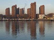
This was followed, in the 1970s, by the red brick towers of the World's End estate which swept away many Victorian terraced houses.[1][2] The estate was designed by Jim Cadbury-Brown and Eric Lyons, and is now known for its brutalist architecture.[3]
Transport
The nearest tube station to the World's End area is Fulham Broadway, however this is a 10-15 minute walk away. Imperial Wharf Overground Station is only 5 minutes walk, and connects with the District Line at West Brompton, the Central Line at Shepherds Bush and so on. Imperial Wharf also provides a direct link to Britain's busiest rail interchange, Clapham Junction, to the South and Willesden Junction in the North. From Clapham Junction, a high frequency of services run from London Victoria and Waterloo through to Brighton, Gatwick and many destinations in the South West of England. Sloane Square is easily accessible via the many and frequent buses which serve the Kings Road route.
References
| Wikimedia Commons has media related to World’s End Estate. |
- Bignell, John. (Ed.) (1978). Chelsea seen from 1860 to 1980: A collection of photographs old and new pp. 96–99. Studio B. ISBN 0-9506228-0-X
- Gullick, John (Ed.). (1975). A place called Chelsea pp. 106–109. City Journals Ltd. ISBN 0-9504471-0-2
- Wheal, Donald James. (2005). World's End: A memoir of a Blitz childhood. Arrow Books. ISBN 1-84413-682-5
- Citations
- ↑ "The World's End Estate, Chelsea: 'Village style living in the heart of London'". Municipal Dreams blog. 29 October 2013. Retrieved 14 December 2015.
- ↑ local studies
- ↑ Jonathan Meades (13 February 2014). "The incredible hulks: Jonathan Meades' A-Z of brutalism". The Guardian. Retrieved 1 November 2015.
| Districts |  | |
|---|---|---|
| Attractions | ||
| Theatres | ||
| Royal Parks | ||
| Street markets | ||
| Parliamentary constituencies | ||
| Squares and streets | ||
| Bridges | ||
| Tube and railway stations | ||
| Pubs | ||
| Other topics |
| |