Wycliffe, County Durham
| Wycliffe | |
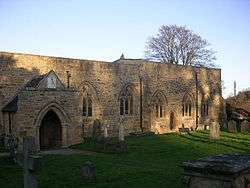 St Mary's Church at Wycliffe |
|
 Wycliffe |
|
| OS grid reference | NZ115143 |
|---|---|
| Unitary authority | County Durham |
| Ceremonial county | County Durham |
| Region | North East |
| Country | England |
| Sovereign state | United Kingdom |
| Police | Durham |
| Fire | County Durham and Darlington |
| Ambulance | North East |
| EU Parliament | North East England |
| UK Parliament | Bishop Auckland |
|
|
Coordinates: 54°31′29″N 1°49′21″W / 54.52471°N 1.82254°W
Wycliffe is a village on the south bank of the River Tees in the North East of England, situated a short distance to the east of Barnard Castle.[1] Wycliffe is in the civil parish of Wycliffe with Thorpe.[2]
It was historically located in the North Riding of Yorkshire but along with the rest of the former Startforth Rural District it was transferred to County Durham for administrative and ceremonial purposes on 1 April 1974, under the provisions of the Local Government Act 1972.
References
- ↑ Ordnance Survey: Landranger map sheet 92 Barnard Castle & Richmond (Teesdale) (Map). Ordnance Survey. 2011. ISBN 9780319228982.
- ↑ "Ordnance Survey Election Maps". www.ordnancesurvey.co.uk. Ordnance Survey. Retrieved 18 February 2016.
External links
![]() Media related to Wycliffe, County Durham at Wikimedia Commons
Media related to Wycliffe, County Durham at Wikimedia Commons
This article is issued from Wikipedia - version of the 3/23/2016. The text is available under the Creative Commons Attribution/Share Alike but additional terms may apply for the media files.